


Tug Hill Prepares for Intense Snowfall: 4 Inches per Hour Expected Monday
The Tug Hill region is bracing for a significant winter storm, with forecasts predicting intense snowfall starting Monday night. The National Weather Service has issued a winter storm warning for Oswego, Jefferson, and Lewis counties.
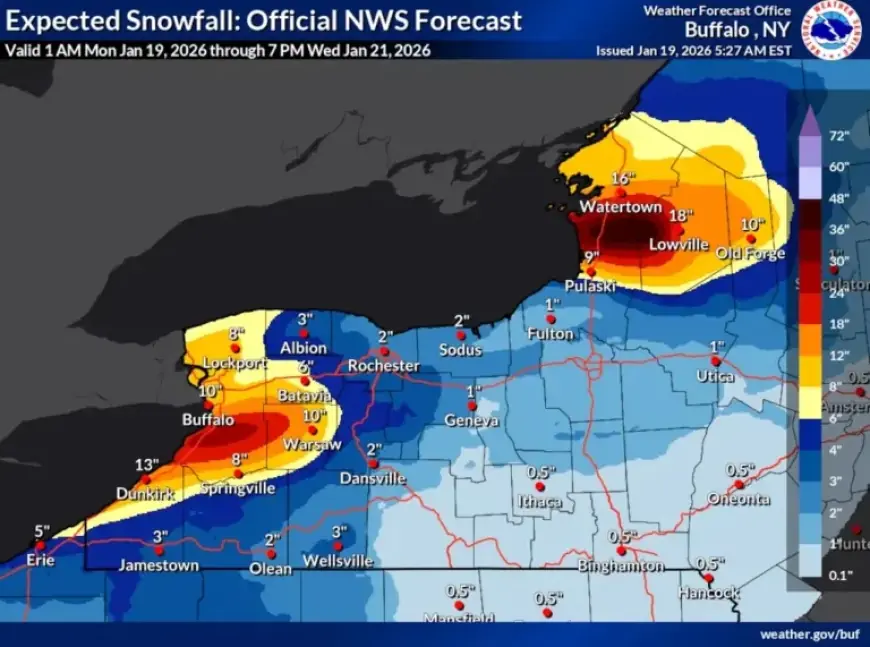
Tug Hill Snowfall Forecast
Snow accumulation is expected to be severe, ranging between 2 to 4 feet across the area. The heaviest snowfall will hit the Tug Hill region, with rates possibly reaching 4 inches per hour from Monday through Tuesday night.
Weather Conditions
Wind gusts may reach up to 45 mph, leading to hazardous conditions due to blowing and drifting snow. Travelers should be prepared for whiteout conditions, making travel extremely dangerous.
- Snowfall Rates: Up to 4 inches per hour.
- Wind Gusts: Potentially reaching 45 mph.
- Wind Chill Values: Expected to drop as low as -15°F.
Temperature Drops and Wind Chill
An arctic front is expected to pass through the region on Monday, bringing frigid temperatures. From Monday night through Tuesday night, wind chill values are predicted to range from 0 to -10 degrees Fahrenheit.
Lake Effect Snow Development
The lake effect snow band originating from Lake Ontario began to develop northeast of the lake early Monday morning. This band is projected to focus on regions east of Lake Ontario, particularly over and north of the Tug Hill area, as well as southern Jefferson County, western Lewis County, and northern Oswego County.
Future Weather Predictions
As the weather evolves, the snow band is expected to shift back north by Tuesday night. Drier air will move into the region by Wednesday morning, leading to a gradual decrease in snowfall intensity. However, another round of lake-effect snowfall is anticipated on Thursday, as temperatures are set to drop once again.
Residents are advised to stay updated on weather conditions and prepare for potentially severe winter weather in the days ahead.


