


Increased Chances for Snow in NY and NJ This Weekend
Increased chances for snow are expected across New York and New Jersey this weekend. The National Weather Service (NWS) has issued a winter weather advisory for certain areas due to a low-pressure system moving through the region.
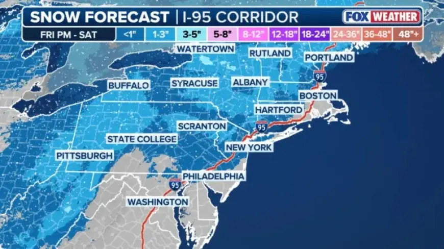
Snowfall Forecast for NY and NJ
Forecasts suggest that 2 to 4 inches of snow may accumulate in some parts of New York and New Jersey. However, New York City is likely to see less than half an inch of snow.
Detailed Timeline
- Friday Night: 40% chance of snow after 1 a.m. with a low around 33°F. Winds from the south at 9 to 11 mph.
- Saturday: Snow is likely before 10 a.m., possibly mixed with rain later in the day. Highs will be near 39°F. Precipitation chance at 60%.
- Saturday Night: Expect a chance of rain before 7 p.m., followed by a slight chance of snow post 1 a.m. Low around 34°F.
- Sunday: A 30% chance of snow mainly after 1 p.m., with a high around 36°F.
Impacts and Considerations
Weather officials emphasize that the highest snowfall totals may occur at higher elevations where temperatures are cooler, allowing snow to persist longer. Current forecasts may change, and residents are advised to stay updated on any developments.
Future Weather Outlook
Looking ahead, the NWS warns that the coldest day in the immediate future will be Tuesday, when temperatures could dip into the upper teens and lower 20s across parts of the region.
Monitoring updated forecasts over the weekend is essential as the timing and impact of incoming weather systems become clearer. This information is crucial for planning and safety in the New York and New Jersey areas.