


Tornado Warning Issued for Southeast Wisconsin Until 8 p.m.
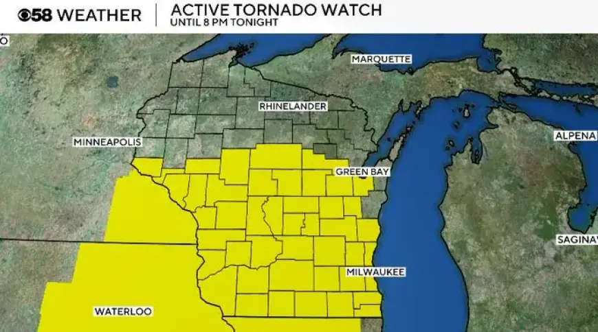
The National Weather Service has issued a tornado watch for southeast Wisconsin through 8 p.m. Friday, April 17. A tornado warning is also in effect for Dodge County until 5:15 p.m.
Active warnings and timing
Severe thunderstorm warnings were active for Dodge and Jefferson counties until 6:15 p.m. That same update showed warnings for Waukesha and Walworth counties until 6:30 p.m.
Two lines of severe storms were moving into the region by mid-afternoon. The lines were merging and had the potential to form a very strong supercell or multiple supercells.
Storm intensity and hazards
Meteorologists warned of extremely large hail. Hail stones could exceed four inches in diameter.
Tornadic wind speeds were forecast as high as 140–170 mph in the strongest cells. Rain accumulations near 1–3 inches were likely with these storms.
Forecast timing and additional rainfall
Forecasters expected storms to begin forming around 3 to 4 p.m., mainly to the west. The severe threat was expected to last into the late evening and should subside by around 11 p.m.
After the intense storms end, moderate steady rain was likely through Saturday morning. Additional rainfall totals of 0.5–1.5 inches were forecast across most areas.
Flooding and recent rainfall totals
This week produced record rainfall across southeast Wisconsin. Milwaukee’s monthly total climbed past eight inches, marking the wettest April on record.
The April average is 3.86 inches. The previous wettest April measured 7.38 inches in 2013. From Sunday through Thursday, Milwaukee recorded more than 3.5 inches.
- West Allis and Menomonee Falls: nearly 7 inches.
- Fond du Lac, Waukesha, Jackson, River Hills: reports above 4 inches.
- Most of southeast Wisconsin: at least 3 inches over the past five days.
Risk levels and primary threats
A Level 3 Enhanced Risk covered much of western Wisconsin, including western and southern local counties. Eastern counties were under a Level 2 Slight Risk as storms could weaken near Lake Michigan.
Forecasters said flash flooding would be the main hazard where storms drop more than a half inch. Tornadoes and damaging wind were listed as the greatest overall threats. Large hail was more likely in western locations.
Safety and tracking
Residents were urged to stay weather-aware and to avoid flooded roadways. Those tracking conditions could use the Filmogaz.com Weather app for live radar and warnings.
Keep a safe plan and monitor updates as conditions evolve through Friday night and into Saturday morning.