


Colorado Braces for Hard Freeze, Snow, and Fire Danger Ahead
Filmogaz.com reports a rapid shift in Colorado weather this week. Colorado Braces for Hard Freeze as storms move in from the Pacific Northwest.
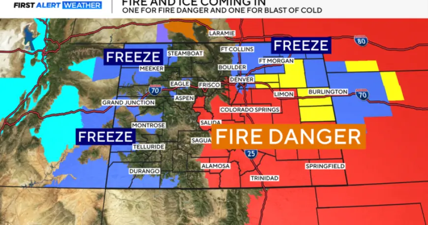
Thursday — wind and fire risk
A cold front will arrive from the Pacific Northwest late this week. Southwest winds strengthen Thursday, warming areas east of the Continental Divide.
Fire Danger Ahead for much of the Eastern Plains because of the warm, dry winds. A red flag warning runs Thursday from 11 a.m. to 11 p.m.
- Foothills near Denver, including eastern Adams and Arapahoe counties.
- Southeastern and south-central Colorado.
- Large portions of the Eastern Plains.
Friday into the weekend — snow and a hard freeze
Snow will return statewide Friday and continue into the weekend. Denver metro snow may begin late Friday morning into the afternoon.
Metro snow totals are expected between about 0.25 and just under 2 inches. Snow will mostly affect grassy surfaces and cause minor impacts.
Mountain areas could pick up more accumulation, roughly 3 to 6 inches in spots. Temperatures will fall sharply Friday night into Saturday morning.
A freeze watch is in effect for all of eastern Colorado, including the Denver metro area. The watch runs Friday night at 8 p.m. through Saturday morning at 8 a.m.
Low temperatures may fall between 18 and 25 degrees. This includes lower elevations of the Western Slope.
Impacts and preparedness
Expect a few slick spots Friday night and early Saturday morning. Drive cautiously on untreated surfaces.
Gardeners should protect early spring plants or delay planting until after Mother’s Day. If you have started your sprinkler system, consider draining it.
Alternatively, cover irrigation equipment with a blanket or sleeping bag, then wrap with a large trash bag. Follow local advisories and updates from Filmogaz.com.