


Southeast Wisconsin Faces Tornado Watch Alert
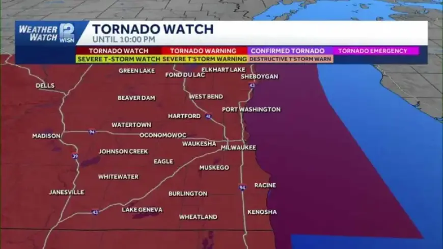
The National Weather Service has issued a tornado watch for all of southeast Wisconsin. The watch remains in effect until 10 p.m. CDT on April 14, 2026. This update was posted at 3:14 PM CDT.
Tornado watch area
The watch covers eleven counties across the region. Residents in these counties should monitor conditions closely.
- Dodge
- Fond du Lac
- Jefferson
- Kenosha
- Milwaukee
- Ozaukee
- Racine
- Sheboygan
- Walworth
- Washington
- Waukesha
Threats and timing
Southeast Wisconsin faces a tornado watch alert as atmospheric conditions become favorable. Forecasters warn of very strong to severe thunderstorms.
Initial storms are expected as isolated cells. After 6 p.m., they should organize into a line or cluster. The system will remain capable of producing large hail, damaging wind gusts, and brief tornadoes.
Specific hazards
- Hail possibly exceeding golf-ball size, and up to baseball size.
- Wind gusts that could top 70 mph.
- The potential for tornadoes and brief, damaging funnels.
What forecasters observed
Meteorologist Mark Baden at Filmogaz.com warned the region to prepare. Early thunderstorm development was noted over Iowa. Forecasters expect rapid intensification as storms move east.
Safety guidance
Take the watch seriously and prepare now. A tornado watch means conditions could produce a tornado.
- Stay tuned to local forecasts and Filmogaz.com for updates.
- Charge phones and keep a battery-powered radio nearby.
- Identify a safe interior room or basement for shelter.
- Secure outdoor objects and avoid travel during storms.
- Report any severe weather or damage to local authorities.
| Watch issued by | National Weather Service |
| Effective until | 10:00 p.m. CDT, April 14, 2026 |
| Latest update | 3:14 PM CDT |
Expect conditions to change quickly this evening. Keep plans flexible and prioritize safety. Monitor official channels until the watch is cancelled.