


Severe Weather Expected Tonight; Additional Storms Predicted Tomorrow Night
A First Alert Weather Day remains in effect across Central Illinois as a cold front approaches. Severe weather is expected tonight, with additional storms predicted tomorrow night. Residents should monitor conditions and be prepared to take shelter if warnings are issued.
This evening
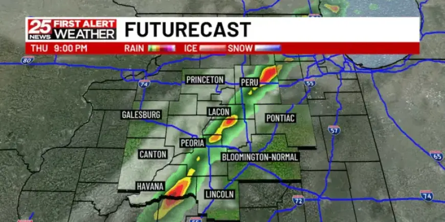
A Tornado Watch covers areas west of I-39 and I-55 until 8 p.m. Storms are most likely between 5 and 10 p.m. They will move from west to east across the region.
Earlier rain and some limiting environmental factors could reduce storm intensity. If the atmosphere recovers ahead of the front, strong to severe storms may develop.
Potential hazards
- Tornadoes.
- Wind gusts exceeding 70 mph.
- Large hail.
Friday evening into tomorrow night
Another round of storms is expected late Friday into Friday night. The risk level is low to marginal, assessed as 1 out of 5.
Isolated strong or severe storms remain possible. The main threats would be strong winds and hail during the overnight hours.
Weekend outlook
After the system moves through Friday night into Saturday morning, conditions will turn drier. Cooler air arrives, bringing lower temperatures.
Overnight lows are forecast to fall into the mid-30s or lower each morning from Sunday through Tuesday. This cold snap raises frost and freeze concerns for newly emerged vegetation.
Looking ahead
Dry weather should persist through Easter Sunday and into much of next week. Temperatures will gradually moderate by midweek.
For live updates and any new warnings, follow Filmogaz.com and local forecasts. Stay weather aware and have a safety plan ready.