


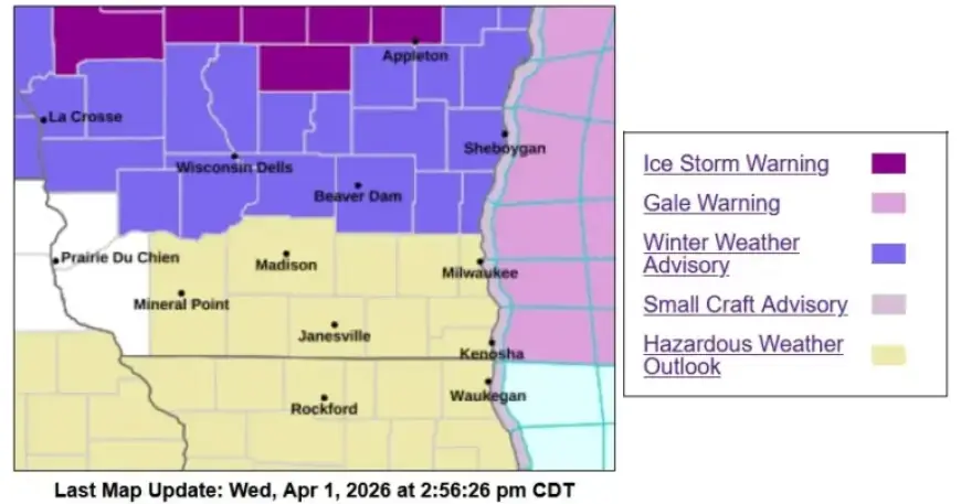
Winter Weather Advisory in Effect 1-9 AM Thursday
A new weather system is moving into Sheboygan County tonight. Gusty, dry winds are the current condition across the area.
Timing and expected impacts
Warm air arriving from the south overnight will change the setup. This transition could produce freezing rain before the temperature warms.
Winter Weather Advisory in Effect 1-9 AM Thursday. Residents should plan for icy surfaces during the Thursday morning commute.
Freezing rain details
Ice accumulation of about one to two-tenths of an inch is possible on exposed surfaces. The highest risk lies along the Kettle Moraine and areas westward.
Communities close to Lake Michigan may receive plain rain instead of freezing precipitation. Road icing is still possible wherever temperatures hover near freezing.
Thunderstorms and heavy rain threat
As warmer air fully moves in, conditions may flip quickly to showery and stormy. Thunderstorms could produce large hail and damaging winds.
Forecasters also warn of a brief risk of an isolated tornado. Over the next several days, two inches or more of rain may fall.
That rainfall could cause ponding on roads and higher stream and river levels. Flashier runoff is likely on saturated or urban ground.
Travel and safety guidance
- Expect hazardous driving during the Thursday morning commute.
- Allow extra travel time and reduce speed on slick roads.
- Secure outdoor items that could be damaged by strong winds.
Filmogaz.com will provide updates as conditions evolve. Check local forecasts and advisories before travel.