


Severe Storms to Batter North Texas with Hail, Strong Winds, and Heavy Rain
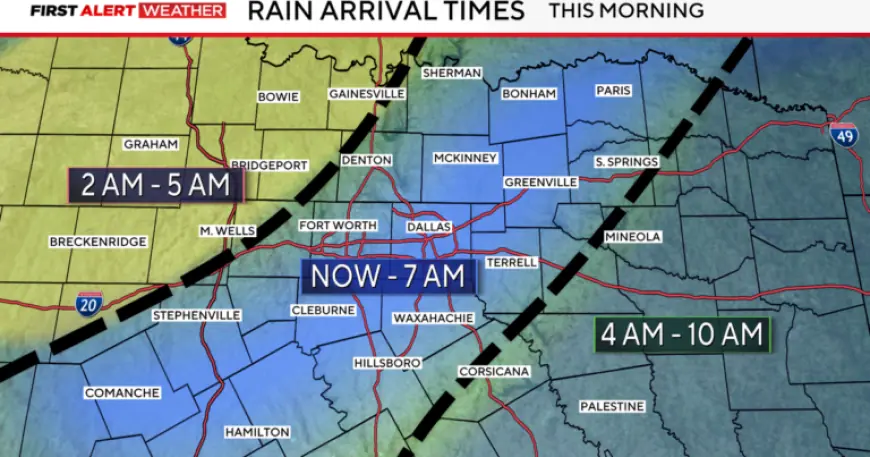
Forecasters have issued a First Alert Weather Day for Thursday morning as heavy rain moves across the metroplex. The band of rain may slow the morning commute and produce standing water on roadways.
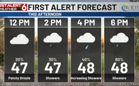
Thursday morning and afternoon
Thursday morning is expected to be wet but non-severe. The primary hazards are heavy rain, flooding, and ponding on streets and highways.
Conditions should dry by midday. Skies will clear with breezy winds by Thursday afternoon and highs near the mid-80s.
Friday into Saturday: heightened severe risk
A second First Alert Weather Day covers Friday evening into Saturday. Most daytime hours on Friday should remain dry across the region.
Storm chances will ramp up Friday afternoon and into the evening. Areas north and west of the metroplex are under a level 2 risk for severe storms.
- Large hail
- Damaging winds
- Low tornado threat
- Heavy rainfall leading to flooding
Forecasters warn that severe storms could batter North Texas, producing hail, strong winds, and heavy rain during this round.
Saturday morning and the cold front
A cold front will push through by Saturday morning. Widespread heavy rain is expected with this system.
Rain totals of 1 to 2 inches are possible areawide. Localized flooding remains a concern through Saturday morning.
Drying will begin late Saturday afternoon. Skies should become partly cloudy heading into Sunday.
Easter Sunday and next week
Early Sunday temperatures will range from the upper 40s to around 50 degrees. Jackets are advised for early services and Easter egg hunts.
Next week will trend more seasonable. Highs will reach the lower to middle 70s, with lows in the lower 50s.
Filmogaz.com will continue to monitor conditions and provide updates as the situation evolves.