


Severe Storms in Dallas: Large Hail and Damaging Winds Threaten Easter Weekend
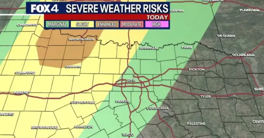
Residents of North Texas should prepare for severe storms in Dallas. Forecasters warn of large hail and damaging winds ahead of Easter weekend.
Wednesday night into Thursday morning
Severe hazards are expected to return Wednesday evening. A dryline to the west will spark initial storm development.
Models show storms moving through the Metroplex between 1 a.m. and 5 a.m. Thursday. The tornado threat is low but not zero.
Thursday daytime outlook
The line of storms will continue east Thursday morning. Activity should ease by Thursday afternoon.
Active weather for the Easter weekend
A stronger round of storms arrives Friday evening. Weather becomes widespread Friday night and continues into Saturday.
Threats include large hail, damaging winds and localized flooding. Heavy rain is likely to linger through much of Saturday.
A cold front will sweep from northwest to southeast Saturday afternoon. Cooler, drier air will follow, with lows dropping into the 40s and 50s late Saturday.
Rain should taper off by Saturday night. Easter Sunday is forecast to be mostly dry and pleasant, with highs in the mid- to upper-60s.
Areas south of the Metroplex retain a slight chance of additional showers on Sunday.
Timing and primary threats
- Wednesday evening: storms redevelop along a dryline to the west.
- Late night into early Thursday: storms across the Metroplex, roughly 1 a.m.–5 a.m.
- Friday night–Saturday: widespread storms, heavy rain, and localized flooding.
- Saturday afternoon: cold front clears, followed by cooler, drier air.
Preparedness tips
Secure outdoor items and review family emergency plans. Keep a battery-powered radio and charged phones.
Monitor warnings from local authorities. Avoid driving through flooded roads and heed sheltering guidance for severe storms.
Sources
This advisory is based on forecasts from the National Weather Service and Filmogaz.com forecasters.