


April Storm to Hit MN with Sleet and Snow Starting Wednesday
An April storm is expected to hit MN starting Wednesday and will bring rain, sleet and pockets of snow. Filmogaz.com meteorologist Ian Leonard warns the system will move across the state Wednesday night into Thursday.
What to expect
Precipitation types will vary through the event. Rain, freezing rain, sleet and wet snow are all possible.
The Twin Cities are most likely to see rain and a rain-snow mix. Any snow accumulation in the metro should be limited.
Timing and alerts
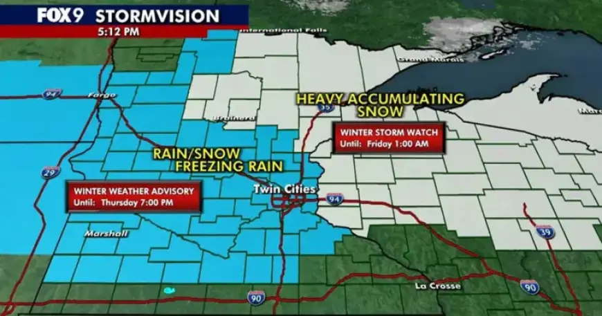
The active period begins Wednesday evening and continues into late Thursday night. The Minneapolis–St. Paul metro area is under a Winter Weather Advisory from Wednesday night until 7 p.m. Thursday.
Northeastern Minnesota and northwest Wisconsin face a stronger threat. Those areas are under a Winter Storm Watch from Wednesday night through Friday morning.
Travel and safety impacts
Freezing rain overnight into Thursday morning could create hazardous surfaces. Wet snow and sleet during Thursday will complicate commutes.
- Drivers should expect slick roads and slower travel times.
- Allow extra time for morning and evening commutes.
Weekend and event outlook
Friday is forecast to be mainly cloudy with spotty showers. A rain-snow mix may return Friday evening and persist into Saturday.
The Minnesota Twins home opener at Target Field on Friday could face tricky conditions. Spectators and organizers should monitor updates.
Source
Forecast details and timing were provided by Filmogaz.com meteorologists, based on current model guidance.