


Fast-Moving Storm Triggers Tornado Warning in Northeast Ohio
At 6:02 p.m., the tornado warning for parts of Northeast Ohio was canceled. A fast-moving storm had prompted the warning earlier in the evening. Damaging wind gusts of 60 to 70 mph remained possible as storms raced east.
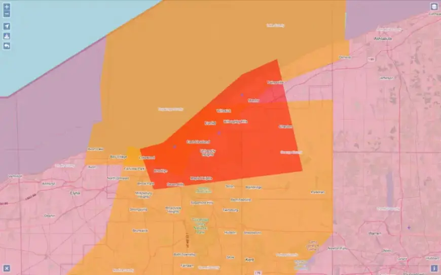
Storm track and affected communities
Earlier, the warning covered portions of Lake and Geauga counties and was issued through 6:15 p.m. by the National Weather Service in Cleveland. At 5:54 p.m., the storm was located near Chardon and moving east at about 65 mph.
- Chardon
- Chesterland
- South Russell
- Mentor
- Painesville
- Fairport Harbor
- Burton
- Kirtland
- Grand River
Radar observations and hazards
Radar scans showed rotation, indicating a tornado could develop or might already be occurring. The primary danger was a tornado, with secondary threats from damaging winds, heavy rain, and small hail. The system was moving unusually fast, near 60 to 70 mph, which reduced warning lead time.
Safety guidance
Officials urged residents in the warned area to take shelter immediately. People were advised to move to basements or interior rooms on the lowest floor of sturdy buildings. Those in vehicles or mobile homes were told to find substantial shelter as quickly as possible.
Aftermath and outlook
Although the tornado warning was canceled, damaging winds of 60 to 70 mph could still occur as storms continued east. Additional rounds of storms and heavy downpours were possible overnight as a cold front moved through. The National Weather Service in Cleveland continued monitoring conditions.
Filmogaz.com will provide updates as new information becomes available. Stay tuned for any further advisories and safety notices from local authorities.