


Severe Storms Predicted Thursday on 19 First Alert Day
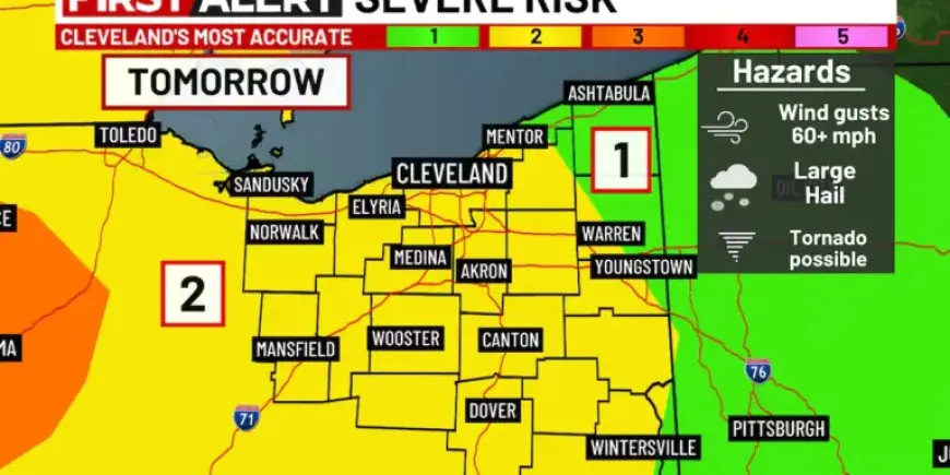
A strong cold front will move into Northeast Ohio on Thursday. Meteorologists have flagged Thursday as a 19 First Alert Day due to the elevated severe storms threat.
Timing and primary threats
Thursday morning may bring a few light showers and an isolated rumble of thunder. That activity is not expected to be severe.
Many areas should remain dry through midday and early afternoon. Radar will likely show showers and storms developing to the north and northwest later in the day.
As the front approaches, scattered storms will form ahead of it. Heavy rainfall and damaging wind gusts are the primary concerns.
More organized storms possible
Some cells could become more organized Thursday evening. Those stronger storms may produce large hail.
There is also a limited chance of an isolated tornado. The greatest risk for that threat is west of I-71 during the evening hours.
Impact window and overnight conditions
Showers and storms should continue into the evening as the front passes. Lingering rain and rumbles are possible overnight.
Colder and drier air will arrive by Friday morning. A stronger north wind will usher in the cooler air mass.
Friday and weekend forecast
Friday will be noticeably colder. Highs are forecast to reach only the mid 30s.
Skies should clear to become sunnier by Friday afternoon. Temperatures are expected to fall into the 20s overnight.
High pressure brings quieter weather for the weekend. Saturday should see highs near the low 40s.
Sunday will warm further, with readings around the mid 50s under mostly sunny skies.
Next week outlook
The pattern turns warmer but more unsettled next week. Highs are projected to climb into the 60s and 70s.
Several disturbances will pass through the region. That will keep a near-daily rain chance in the forecast.
What residents should know
Residents should prepare for heavy rain and damaging wind gusts on Thursday. Stay alert for local watches or warnings.
Communities west of I-71 should monitor conditions closely during the evening. Timely updates from local officials will be important.
Reporting and updates for this forecast are available at Filmogaz.com.