


Snowfall Tonight; Expect Quieter, Warmer Weekend Ahead
A band of light snow will move across portions of Minnesota, northern Iowa and western Wisconsin this afternoon and evening. Conditions will calm and temperatures will rise as the system finishes and a warm pattern builds into the weekend.
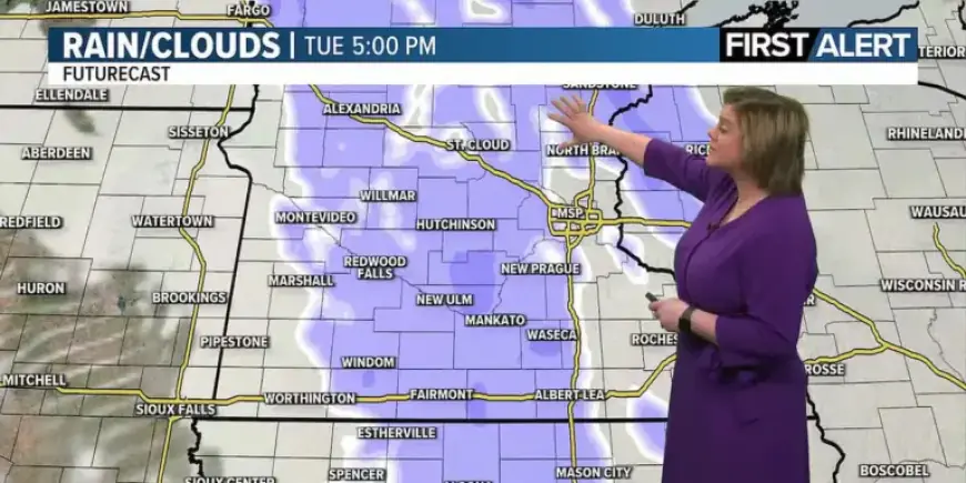
Timing and track
Snow moves eastward from the western region this morning. The western zone, including northwestern Iowa and parts of west-central and northwestern Minnesota, should see snow between 10 a.m. and noon.
Showers will reach central areas this afternoon. Expect snow between about 3 p.m. and 5 p.m. from northcentral Iowa through southcentral and northcentral Minnesota.
After 5 p.m., the line will continue east, reaching western Wisconsin late tonight. The system will gradually weaken as a warm front passes.
Mankato timing
Mankato is forecast to have snow ending between 8 p.m. and 10 p.m. this evening. Local timing may shift with the weakening trend.
Snow totals and impacts
Accumulations will be light across most areas. A dusting to one inch is most likely.
Isolated spots along the Minnesota–Wisconsin border could see up to two inches. Impacts should remain minor.
Roads may become slick tonight and again tomorrow morning. Motorists should use caution during travel.
Temperature trend and forecast
Temperatures will warm through today and overnight. Afternoon highs will be in the upper teens to low 20s.
Early Wednesday morning readings should climb into the mid-20s as skies stay mostly cloudy after the snow. Expect snowfall tonight to end before the warming trend takes hold.
From Wednesday onward, conditions look generally quiet. The pattern favors rising temperatures into the rest of the week and weekend.
Precipitation chances this week
- Wednesday night: a light rain chance during overnight hours.
- Saturday night into Sunday morning: another light rain possibility overnight.
- No other notable precipitation is expected through the extended forecast.
Weekend outlook and winds
Much of the area will see 40s from Wednesday through the following Thursday. Friday and Saturday look especially mild.
Highs may reach the mid-50s on Friday and Saturday. Expect a quieter, warmer weekend ahead compared with current conditions.
Winds will increase later in the week. Speeds will rise from 5–10 mph through Thursday to 10–20 mph from Friday onward.
Gusts up to 30 mph are possible Friday through the following Thursday. Overnight lows will generally fall into the 30s and 40s.
This forecast summary was prepared for Filmogaz.com based on local model guidance and timing estimates. Check local updates if travel is planned tonight.


