


Recent Low Country Quakes Highlight South Carolina’s Violent Seismic History
Residents near Charleston felt the ground move this week after a pair of small earthquakes struck the Lowcountry. The U.S. Geological Survey recorded the events and logged hundreds of public reports.
This week’s seismic activity
A 2.3 magnitude quake rattled Centerville on Feb. 3. Late Saturday night, a 2.9 magnitude tremor occurred near Centerville at 10:37 p.m.
That 2.9 event registered at about three miles depth. It was the strongest quake recorded in South Carolina in nearly six months.
Seismologists noted the 2.9 quake was the largest since a 3.0 magnitude event near Coronaca on Aug. 23, 2025. Additional small shocks were reported in the area each day that week.
Impact and official response
More than 800 people reported feeling the Saturday quake to the USGS. Officials called the recent tremors likely aftershocks of the late-night event.
The South Carolina Emergency Management Division said no major damage or injuries were reported. Local agencies continue to monitor seismic activity in the Lowcountry.
Historical context
Lowcountry quakes in recent days recall the state’s violent seismic history. South Carolina has produced some of the Eastern Seaboard’s most powerful earthquakes.
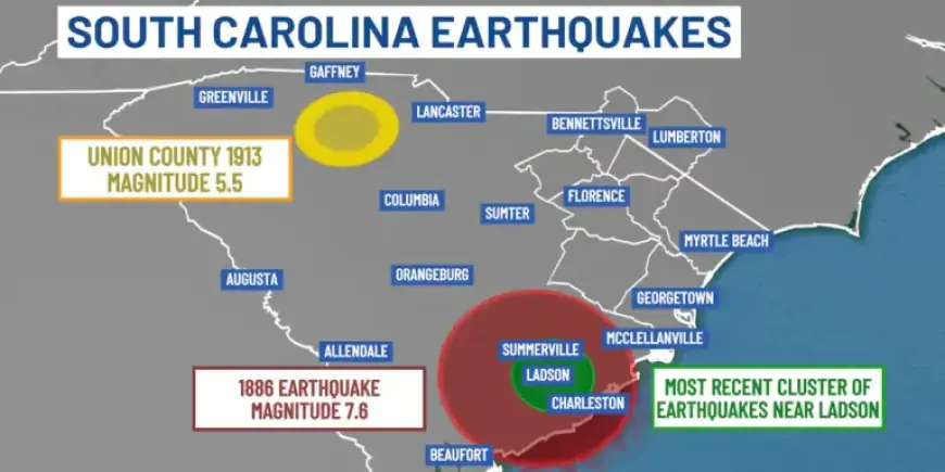
The most destructive occurred on Aug. 31, 1886, near Charleston. That quake, estimated at magnitude 7.6, killed about 60 people and demolished many brick buildings.
Shaking from 1886 damaged structures up to 200 miles away. The event was felt across about 2.5 million square miles, from Cuba to New York and Bermuda to the Mississippi River.
Another notable event struck Union County on Jan. 1, 1913. That Piedmont quake measured about magnitude 5.5, caused little damage, and produced no fatalities.
Geologists have found evidence for at least five large prehistoric quakes in the region over the last 5,000 years. They identified sand blows, vents, fissures, and landslides preserved in coastal soils.
Why earthquakes happen here
Most of South Carolina’s earthquakes are intraplate events. They occur within the North American plate rather than at plate boundaries.
Scientists suggest stresses from plate margins or reactivated ancient faults may trigger these shocks. Hidden faults in the Coastal Plain lie buried beneath thick sediments and are hard to detect.
The South Carolina Geological Survey continues mapping faults and geologic structures. Officials use geophysical methods and seismic records to better locate these features.
Monitoring and preparedness
Predicting the exact timing and location of earthquakes remains impossible. State agencies advise residents to prepare for the possibility of a stronger quake within state borders.
The Geological Survey is producing seismic-hazard maps for the Coastal Plain. Those maps aim to show areas most susceptible to severe ground shaking and support mitigation planning.
Residents can sign up for the USGS Earthquake Notification Service for alerts by email or phone. Local outreach emphasizes education, readiness, and monitoring.
Report compiled for Filmogaz.com using U.S. Geological Survey and state agency information.


