


Red Flag Warning in Colorado as Xcel Plans Possible Power Shutoffs for 18,000 Customers
A red flag warning is in effect from 11 a. m. to 9 p. m. Saturday as high winds and very low humidity raise wildfire concerns across parts of Colorado—and could trigger preemptive power shutoffs for thousands of customers in Boulder and Jefferson counties.
Red Flag Warning Conditions Drive Fire Risk on Saturday
Forecasters are calling for warm, dry and windy conditions that significantly increase the risk of rapid wildfire spread. A Red Flag Warning is in place across the Denver metro area and much of eastern Colorado through Saturday evening, with critical fire weather driven by a combination of low relative humidity and strong winds.
Along the Front Range and eastern plains, temperatures are expected to climb into the mid to upper 70s, while humidity drops as low as 7% to 14%. In Boulder and Jefferson counties, the National Weather Service cited low relative humidity and wind as the key factors behind the warning. Winds are expected to persist between 20 and 30 mph, with gusts up to 50 mph, and relative humidity could reach as low as 10%.
Winds are expected to strengthen through the day, with sustained west winds around 25 to 30 mph and gusts of 40 to 60 mph, particularly during the afternoon. Near the foothills—including parts of Boulder County and northern Jefferson County—brief gusts could reach around 70 mph between 1 p. m. and 5 p. m. Saturday evening.
Xcel Energy Says 18, 000 Customers Could Lose Power Around 2 p. m. Saturday
Xcel Energy says it is planning for a public safety power shutoff amid the high winds and fire danger, warning that about 18, 000 customers in Boulder and Jefferson counties could have their power shut off Saturday around 2 p. m. The utility had initially said 43, 000 customers could be impacted, but said in a Friday afternoon release that it had reduced the number that could be affected; the release did not say why the number changed.
In Boulder County, areas in the foothills, the Hill neighborhood in Boulder, and the University of Colorado Boulder’s campus fall within the possible shutoff zone. Some of Gunbarrel and other areas east of Colorado 119 also appear to be included. The Pearl Street Mall and the majority of north and south Boulder do not appear to be in the shutoff zone.
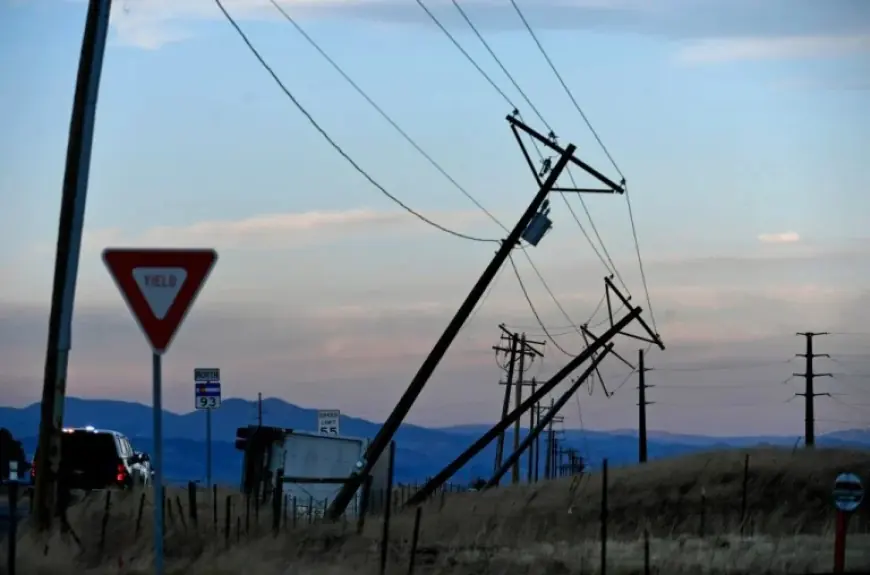
In Jefferson County, areas near Colorado 93 south of the Rocky Flats National Wildlife Refuge and north of Interstate 70 appear to be in the possible shutoff zone.
The utility urged people who use medical equipment requiring electricity to begin preparing for potential outages.
Unplanned Outages Possible, With Wind and a Sharp Shift in Weather by Sunday
Even beyond any planned shutoff, high winds could cause unplanned outages throughout the weekend. Xcel said it may take several hours or several days to restore power because crews must patrol the entire power line before re-energizing it, and crews will begin work once high winds and fire risks have ended. The utility said it is likely outages will continue into Sunday.
As of 4: 45 p. m. Friday, about 1, 441 customers in the Boulder County foothills remained without power after more than 5, 000 in the county lost power amid high winds on Thursday.
Colorado’s weather is expected to swing sharply late Saturday night into Sunday. A powerful cold front is expected to move through the Denver metro area around midnight, bringing a sudden wind shift and a burst of precipitation. Behind the front, north winds could gust between 55 and 65 mph, with temperatures dropping quickly below freezing.
Snow is expected overnight into early Sunday morning, with most lower-elevation areas—including the Denver metro area—possibly seeing a dusting up to about 1 inch, while the Palmer Divide may see 1 to 3 inches. Forecasters say the bigger issue Sunday will be continued strong north winds—potentially with gusts near 60 mph—combined with much colder air, keeping daytime conditions feeling significantly colder.


