


Chicago Weather Turns Sharply Colder Saturday Before Rain, Thunderstorms And Snow Threaten By Monday
Chicago is staying chilly and mostly cloudy on Saturday, but the bigger weather story is the fast-changing system set to swing through the city late Sunday into Monday with rain, thunderstorms, strong winds and a sharp return to winter conditions.
As of mid-morning Saturday, conditions in Chicago were overcast with temperatures in the mid-30s. The forecast calls for a high near 39 degrees Saturday, followed by a warmer and much more active Sunday, when temperatures could surge into the upper 50s to around 60 before crashing again behind the storm.
What Chicago Looks Like Today
Saturday is shaping up as the calmest part of the next three-day stretch.
Cloud cover is expected to hold across the city through much of the day, with temperatures struggling to get out of the upper 30s. Winds are lighter than the damaging gusts that swept through parts of the region on Friday, when some areas in northern Illinois saw gusts above 60 mph.
For most people in the city, Saturday is less about hazardous weather and more about a brief pause before the next round of impacts arrives.
Sunday Brings The Bigger Weather Shift
The forecast turns much more unsettled by Sunday as a strong spring storm approaches the Chicago area.
Rain is expected to develop, and forecasters are warning that showers and thunderstorms may move through Sunday afternoon and evening. The main concern is damaging wind gusts rather than frequent lightning. That can make the setup more deceptive, because some of the strongest weather may arrive in a fast-moving band of storms with little lead-up.
Temperatures are expected to jump well above Saturday’s levels, reaching the mid-50s to near 60 in and around Chicago before colder air sweeps in.
That combination of warmth, wind and storms is the key reason Sunday stands out as the most volatile day in the short-term forecast.
Strong Winds Could Be A Major Problem Again
Wind damage is already fresh in the region after Friday’s storm brought down trees and power lines in parts of northern Illinois and northwest Indiana.
Now another round of powerful gusts is in play as the Sunday system moves east. Forecast discussions for the Chicago area indicate a threat of severe storms east of Interstate 55, with damaging winds the primary hazard. Even outside thunderstorms, gusty conditions may create travel issues, especially for high-profile vehicles and anyone driving on exposed roads.
For city residents, that raises the possibility of scattered power interruptions, difficult evening travel and rapidly changing conditions by late Sunday.
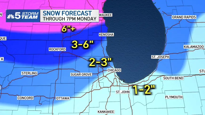
Rain Could Flip To Snow By Sunday Night
The most dramatic part of the forecast may come after the warmer air leaves.
Forecasters expect rain Sunday evening to mix with and then change to snow overnight into early Monday as temperatures plunge. By Monday, Chicago is expected to be back in the 20s, with snow showers, strong northwest winds and the potential for reduced visibility during the morning.
That kind of rapid transition can create slick roads and hazardous commutes, particularly if wet pavement freezes as colder air rushes in.
The city may not see a prolonged snowstorm, but even a shorter burst of snow combined with blowing conditions could cause problems.
What To Watch Over The Next 48 Hours
The most important timing window for Chicago runs from Sunday afternoon through early Monday.
Saturday should remain manageable, with mostly cloudy skies and cold temperatures. Sunday then turns warmer, wetter and windier, with thunderstorms possible later in the day. Overnight, the system is expected to pull colder air back into the region, changing rain to snow and setting up a blustery, colder Monday.
For anyone with weekend travel plans, the safest assumption is that the weather will not stay steady for long. Chicago’s forecast is moving from quiet March chill to spring storm conditions and then back to a winter-style blast in less than two days.


