


Hawaii Kona Storm Triggers Flash Flood Warnings, Road Closures Across Islands
An expansive kona low is pulling deep tropical moisture over the state, and the hawaii kona storm has prompted extended flash flooding, damaging wind gusts and widespread road closures across multiple islands.
First Alert Declared as Heavy Rain, Strong Winds Move In
The First Alert Weather Team declared a FIRST ALERT WEATHER DAYS as a large Kona storm moves north of the state and draws up intense tropical moisture. Forecast guidance indicates an extended period of heavy rain, damaging winds and strong thunderstorms through Saturday morning, with conditions shifting east into Maui County and Hawaii Island through much of Saturday afternoon and evening.
Southerly to southwesterly winds are expected to be strongest from the current period and could produce damaging gusts. South shore surf is peaking just below advisory levels. Snow and ice are possible over the highest Big Island summits as part of the multi-hazard setup.
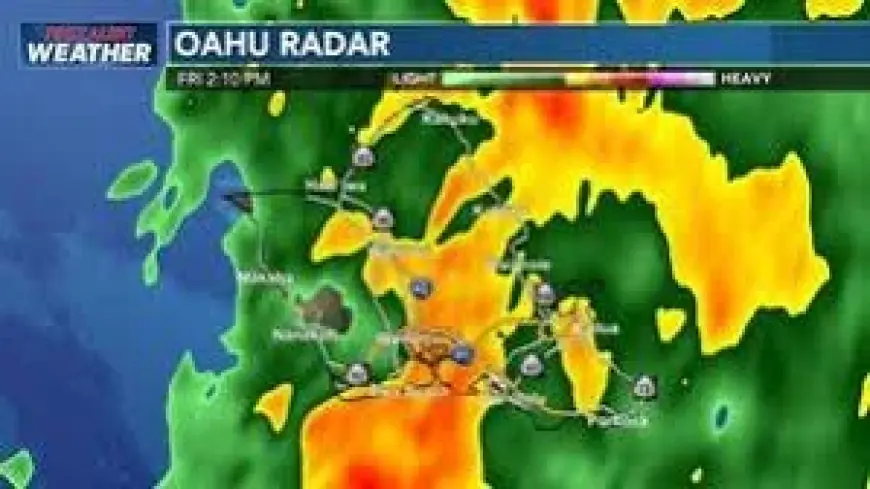
Flash Flood Warnings And Road Closures Persist On Multiple Islands
Flash flood warnings remain in effect across several islands as heavy rainfall continues to cause flooding and closures. The National Weather Service extended flash flood warnings for Oahu and Hawaii island until 12: 30 am ET and for Molokai until 12: 00 am ET. The flash flood warning for Maui was extended until 3: 00 am ET as downpours continue to impact south-facing areas from Maalaea Bay through Kihei and Makena to Kipahulu.
Emergency officials reported multiple road closures and impacts: Wood Valley Road on the Big Island is closed in both directions due to flooding; several roads in Kihei and Lahaina are closed because of significant inundation; and high water has been reported flowing across Kamehameha Highway on Molokai, where the roadway near mile marker 6 remains passable only to four-wheel-drive vehicles. The Kawela Gulch stream gauge is elevated, and water has flowed over Kamehameha Highway at the Kamalo Dip between mile markers 10 and 11, though that location remained passable at the latest update.
Where The Main Rainbands Will Stall And What That Means
Morning conditions on Kauai and Oʻahu featured a line of thunderstorms that will continue through the day, with threats of dangerous winds, heavy rain and localized flooding. Forecasters expect the main band of heavy showers to shift eastward and settle over Maui County and the Big Island, where flash flooding risks will remain elevated.
Through the afternoon, thunderstorms are expected over the eastern half of the state, and the initial band could stall over eastern Maui into the evening. Pop-up thunderstorms and scattered activity are likely on Hawaii Island while strong south winds persist. Current guidance hints at higher rainfall totals on the Kona side of Hawaii Island as the principal rainband remains nearly stationary.
During the night the stalled band could linger between Maui and Hawaii Island, worsening the flood threat. Flooding is expected to begin easing for Kauai and Oʻahu over the coming day, but soils will be saturated enough that any additional rainfall could produce rapid runoff and renewed flash flooding. Flash flooding and breezy southwest winds are expected to continue for Maui County and Hawaii Island into Sunday, with the threat potentially extending further for Hawaii Island.
Authorities continue to monitor conditions as the storm moves across the state overnight. Uncertainties remain about the exact placement and persistence of the stalled rainband, and any localized intensification would raise short-term runoff and roadway hazards.


