


Winter Storm Iona puts I-94 travelers on alert for Sunday hazards
For anyone planning to be on the road near the I-94 corridor this weekend, winter storm iona is becoming the detail that shapes every decision: when to leave, whether to delay, and how long it may take to get there. Forecasters expect a major late-season system to spread snow and strong winds across the Upper Midwest, with conditions turning hazardous as the storm settles in.
Sunday’s First Alert Weather Day and the I-94 corridor
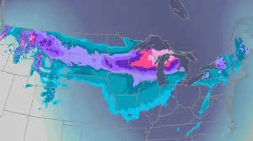
The First Alert Weather team has declared Sunday a First Alert Weather Day, a signal that travel could become especially difficult once the storm is underway. The greatest impacts are expected from roughly the I-94 corridor to points north, where forecasters place the region in a high-impact zone. Several inches of snow are likely, and double-digit totals are expected in that zone, a forecast that can quickly turn routine weekend plans into careful route checks and last-minute calls to reschedule.
Snow is expected to develop through Saturday evening and continue through much of Sunday. Forecasters describe the early snow as a little wet, with temperatures in the 20s to around 30 degrees, a range that can weigh down snow while also adding to road slickness as it accumulates. There has been some indication of a wintry mix in the area, and there is uncertainty about how far north it reaches. That detail matters because it could cut into snowfall totals, changing where the heaviest snow ultimately falls.
National Weather Service Winter Storm Warning from Saturday evening into Monday
As confidence increases that the greatest impacts will occur along and north of I-94, the National Weather Service has issued a Winter Storm Warning from Saturday evening into Monday. The timing captures the storm’s full arc: the onset of snow Saturday night, the peak impacts expected Sunday, and lingering trouble into Monday as the warning remains in place.
The forecast emphasizes how quickly conditions can change once snow develops Saturday night. Clouds are expected to spread across the Upper Midwest through Saturday, with conditions remaining dry through the afternoon before snow chances increase. That window—dry roads giving way to fast-worsening travel—can be one of the most difficult shifts for drivers to navigate, especially when plans were made earlier in the week under calmer expectations.
While snowfall totals draw attention, the wind forecast adds another layer to the risk. Strong northeast winds of 15 to 30 mph are expected to accompany the snow, creating significant blowing and drifting. The combination is expected to make travel particularly hazardous throughout the day Sunday, as drifting can fill in lanes and blowing snow can reduce visibility even when snowfall rates fluctuate.
A Colorado low-pressure system crossing the Plains toward the Midwest
Forecasters describe the storm as a typical Colorado low-pressure system that will cross the Plains before moving northeast through the Midwest. The system is expected to strengthen quickly while pulling high amounts of moisture up from the south, a setup that can support significant snowfall accumulations across a wide area.
Forecast models have come into better agreement on the storm’s track and intensity, a shift that supports the growing confidence behind the warning and the Sunday designation. Even so, the forecast notes an open question about the wintry mix and how far north it will extend, a boundary that could change totals in specific communities and reshape where the sharpest travel impacts settle in.
For now, the clearest message lands back where many weekend plans begin: on the map and along the routes people intend to take. If travel is necessary—especially on Sunday—forecasters urge people to monitor the forecast closely. For drivers who pass signs for I-94, winter storm iona is expected to turn that familiar corridor into the dividing line between difficult travel and the most disruptive conditions, with roads deteriorating quickly once snow arrives Saturday night and the warning stretching into Monday.


