


Winter Storm Watch 2026: Explosive System to Hit 200 Million as Ice Storm Warning and Blizzard Threaten Midwest This Weekend
A powerful new weather system is taking direct aim at the central and eastern United States this weekend and into early next week. A winter storm watch and ice storm warning are active across multiple states as forecasters warn the storm could become a bomb cyclone by Sunday night, threatening nearly 200 million people with blizzard conditions, damaging ice, severe thunderstorms, and dangerous travel.
Winter Storm Watch Friday: Clipper Punches the Northern Tier First
The effects of the main storm this weekend will be preceded by a potent clipper system traveling along the northern tier of the Midwest and Northeast into Friday night. That storm is delivering heavy snow and blizzard conditions across the northern tier, along with far-reaching strong winds stretching from the Rockies to the Atlantic coast.
Active winter storm warnings are in place through Friday across Montana, Wisconsin, Michigan, Minnesota, and Maine, with more than three feet of snow forecast in some elevated areas. In Michigan's Upper Peninsula, warnings cover Alger, Delta, Luce, Northern Schoolcraft, and Southern Schoolcraft counties, with snowfall forecast between 5 and 11 inches and wind gusts up to 40 mph.
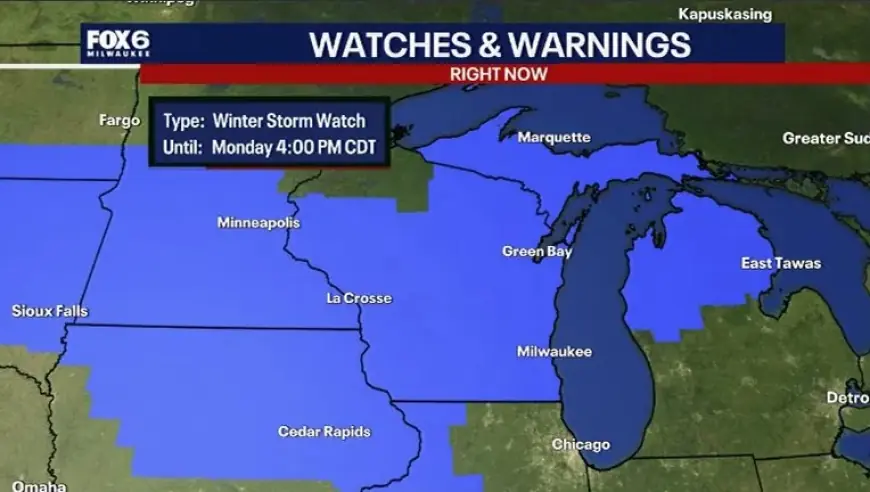
A winter storm watch is in effect for portions of Wisconsin from Saturday evening through Monday afternoon, covering east central, south central, and southeast parts of the state. Heavy snow, blowing snow, sleet, and freezing rain are all possible, with accumulating ice increasingly likely along and north of Interstate 94.
Ice Storm Warning and Bomb Cyclone Threat Sunday Into Monday
A powerful storm will rapidly intensify across the central United States from Sunday into Monday, bringing widespread disruptions for millions. The storm has the potential to become a bomb cyclone, which occurs when central pressure drops at least 0.71 inches of mercury — or 24 millibars — in 24 hours or less. That rapid strengthening would generate an expansive and intense wind field affecting dozens of states.
Blizzard conditions are possible in portions of Wisconsin, Michigan, Iowa, northern Illinois, and southeastern Minnesota. Enough snow to shovel and plow will extend from parts of the Dakotas to northern Michigan. Actual temperatures may drop to the teens and single digits, with wind chills near or below zero across that corridor.
Schools in parts of the Midwest not currently on spring break may close early next week as the storm moves through, with those returning from spring break facing significant travel disruptions.
States in the Path of the Winter Storm Watch and Ice Storm Warning
A separate winter storm warning remains active for the Washington Cascades through March 14, with up to 25 total inches of snowfall and gusts up to 38 mph expected to shut down mountain passes. Drivers on Interstate 90 through Snoqualmie Pass and Highway 2 through Stevens Pass should expect severe delays and potential road closures.
Here is a breakdown of the key threat zones by region this weekend:
| Region | Primary Threat | Timing (ET) |
|---|---|---|
| Upper Midwest (WI, MI, MN, IA) | Blizzard, heavy snow | Sunday night–Monday |
| Northern Plains (MT, ND, SD) | Heavy snow, wind | Friday–Saturday |
| Pacific Northwest (WA Cascades) | Heavy mountain snow | Through Saturday |
| Central/Eastern U.S. (IL, OH, IN) | Severe storms, flooding | Sunday–Monday |
Flight Cancellations and Power Outages Expected to Climb Into the Thousands
Flight delays and cancellations from Sunday through Monday night could climb into the thousands. Major hubs including Denver, Chicago, Detroit, Atlanta, Pittsburgh, New York, Philadelphia, Boston, Washington, and Charlotte may be affected, along with numerous connecting airports. Power outages could reach the tens of thousands to hundreds of thousands, coming just days after a powerful windstorm already swept from the Rockies to the Northeast.
What an Ice Storm Warning Means for Residents
An ice storm warning is issued when ice accumulation of around one-quarter inch or more is expected. This amount of ice accumulation makes travel dangerous or impossible and is likely to cause snapped power lines and falling tree branches. Travel is strongly discouraged under an ice storm warning. A winter storm watch, by contrast, means conditions are favorable for a significant winter storm event — including heavy sleet, heavy snow, ice storm, or blowing snow — but the event has not yet begun.
The National Weather Service urges residents in all affected zones to monitor local alerts closely and avoid unnecessary travel from Saturday night through at least Monday evening.


