


High Wind Warning, Wind Advisory Alerts Span Rockies to Northeast as Dangerous Storm Sweeps Across U.S. Today
A powerful cold front is driving a sprawling wind event across the United States Thursday, with high wind warnings, wind advisories, and high wind watches stretching from Colorado and Idaho through the Midwest and into Ohio — and a second, potentially stronger round already taking shape for Saturday.
High Wind Warning Active Across Colorado and Idaho
Colorado is taking the hardest hit today. The 9NEWS Weather Impact Team issued a Weather Impact Alert for Thursday due to high winds over the Front Range mountains and foothills, with gusts potentially reaching 90 mph near Boulder and Fort Collins. That's not a typo.
A High Wind Warning and High Wind Watch are in place for the foothills and Front Range mountains, with sustained westerly winds of 35 to 45 mph and extreme gusts possible. Some highways, including portions of Interstate 25 and Colorado Highway 93, are closed. A Red Flag Warning is simultaneously in effect for Denver and eastern Colorado, layering fire danger on top of the wind threat.
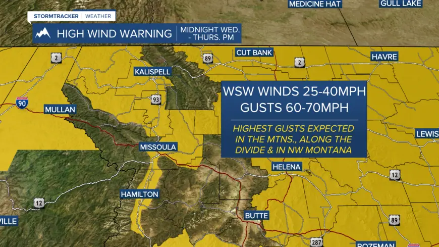
In Idaho, the National Weather Service offices in both Pocatello and Missoula issued High Wind Warnings covering a wide swath of the state. The warning covers areas including Idaho Falls, Rexburg, Blackfoot, Pocatello, and communities along the I-15 corridor, with sustained winds of 30 to 40 mph and gusts to 60 mph through 9 PM ET tonight.
Lemhi County faces the most severe conditions in the state, with west winds of 30 to 40 mph and gusts reaching 70 mph. Widespread power outages are expected there, and travel will be difficult for high-profile vehicles.
Wind Advisory Covers Iowa, Illinois, and the Upper Midwest
The storm system isn't stopping at the Rockies. High Wind Warnings covering portions of north-central and northwest Illinois and east-central Iowa go into effect Friday from 4 AM to 3 PM ET, with west winds of 25 to 30 mph and gusts to 60 mph. Damaging winds will blow down trees and power lines, and widespread outages are expected.
A Wind Advisory precedes the warning tonight across the same zones, with southwest winds of 25 to 30 mph and gusts to 45 mph. Farther south, a Wind Advisory covers southern Iowa beginning at 3 PM ET today through Friday morning, with gusts near 50 mph.
The National Weather Service confirms widespread high winds are impacting the interior Northwest, northern Plains, and Upper Midwest Thursday, with a storm tracking into the Great Lakes and Northeast expected to bring heavy snow and gusty winds through Saturday.
High Wind Watch Posted for Ohio Counties Friday
Ohio is next in line. High Wind Watches are in effect for Friday from 8 AM to 8 PM ET across multiple northeast Ohio counties, including Cuyahoga, Summit, Geauga, Lake, Lorain, Ashtabula, Erie, Huron, Medina, Ashland, Holmes, and Tuscarawas counties. A watch means conditions are favorable for a High Wind Warning to be issued — residents should prepare now.
The broader storm system has already generated Winter Storm Warnings from the Rocky Mountain Front through Montana, Wisconsin, Michigan, Minnesota, and into Maine, with forecast snowfall reaching three feet in some areas and wind gusts hitting 100 mph in blizzard-condition zones near Montana's high-elevation passes.
Saturday Could Be Worse
Forecasters are already flagging the weekend. Saturday winds may exceed 70 mph across Idaho, with warnings and watches likely. The cold front that is driving Thursday's event ushers in a shower chance for Friday before another, more powerful wind event develops Saturday.
Critical fire weather conditions are also developing Thursday across the central and southern Plains and south coastal Texas, where gusty winds combine with low relative humidity. Residents across all warned zones should secure outdoor objects, avoid unnecessary travel — especially in high-profile vehicles — and stay clear of windows during peak gusts.


