


El Niño’s return signals rapid Pacific warming and risks
NOAA observations and seasonal models confirm that el niño is emerging in the equatorial Pacific, driven by subsurface heat and eastward-moving Kelvin waves that model ensembles now project will produce a strong to very strong event before the end of the southern summer. This shift reveals a rapid end to a weak La Niña and raises immediate risks of droughts, floods and higher global temperatures.
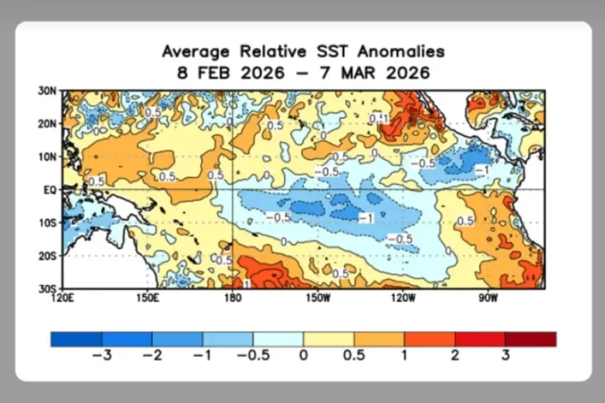
El Niño signs from NOAA
NOAA has detected significant subsurface warming and Kelvin waves transporting heat toward the eastern Pacific, and the main seasonal models have flipped from 60–70% odds of neutral conditions to an 80% probability of a strong or very strong event within a single week; scientists have also observed three episodes of warm water moving east and changes in wind patterns. The pattern suggests these rapid oceanic and atmospheric shifts resemble the lead-up to the 1997 super El Niño, which is estimated to have subtracted about $5. 7 trillion from global economic growth.
ECMWF outlook for Chile
The European Centre for Medium-Range Weather Forecasts (ECMWF) is now flagging a probable arrival of El Niño for Chile, and meteorologist Jaime Leyton projects impacts from the Coquimbo region down to La Araucanía. Leyton characterizes the event as a normal to moderate Niño, not a strong one, and expects it to establish in late autumn with a 60%–70% chance of increased precipitation in the central zone and an extension of winter-like conditions into spring across Coquimbo, Biobío and La Araucanía. The figures point to a regional shift toward wetter central Chile and continued cool-season conditions into spring, increasing flood and water-management pressure for those regions.
Inocar monitoring in Ecuador
ECMWF outputs have also raised the possibility of a strong or even very strong El Niño by late 2026, a signal echoed by climate scientists Daniel Swain and Zeke Hausfather who link such an event to higher global temperature estimates for 2026 and a strong chance that 2027 would be the warmest year on record. Projections show El Niño could produce drought in Australia, Indonesia, eastern Africa and the Caribbean while bringing torrential rains to Peru, Ecuador and Hawaii. That said, Commander Santiago Coral, coordinator of oceanographic affairs at Inocar, warns it is premature to declare el niño for Ecuador: Inocar’s monitoring shows normal conditions in Niño 3+4 and Niño 1+2 and no current oceanic alterations.
For now, the Inocar assessment anchors an important counterpoint: strong model signals exist, but Ecuador’s coastal ocean temperatures and regional indicators remain within historical norms. The pattern suggests that national impacts in Ecuador will depend on whether the subsurface heat and eastward movement observed now persist long enough to alter Niño 1+2 and Niño 3+4 basins.
ENSO development also follows a known seasonal clock: these phenomena begin forming from late April, certain effects can be evaluated in September and October, and the seasonal peak typically falls between November and March. If the subsurface warming detected by NOAA persists into late April, the available data suggests a materially higher chance that the central Pacific will transition into a strong El Niño by the November–March peak season; if those ocean signals dissipate before late April, the likelihood of a major event will fall back toward neutral conditions.


