


Northern Plains Communities Brace as Storm Brings Wind and Heavy Snow
Residents across the Northern Plains are preparing for a pair of powerful weather systems as a storm moves through the region. Forecasters say the two systems will produce extremely strong winds and heavy snow across the Northern Plains, Upper Midwest and Great Lakes through March 15 (ET), with additional lake-effect snow possible afterward.
Northern Plains Communities Face Strong Winds from Montana to Nebraska
Across Montana, Wyoming and the western Dakotas into Nebraska, gusts will be a primary hazard as the first system deepens near the U. S. -Canada border. Forecasts cite widespread wind gusts south of the low track of 50-60 mph and peak gusts over 70 miles per hour in those areas, creating travel and visibility challenges for towns and roadways in the Northern Plains.
Storm Clipper Enters the Pacific Northwest on March 11 (ET) and Moves into the Northern Plains on March 12 (ET)
The first system is expected to act like a clipper, moving into the Pacific Northwest on March 11 (ET) and into the Northern Plains on March 12 (ET). That clipper will encounter a sharp temperature contrast from the Canadian Prairies, where temperatures are forecast in the 20s and 30s Fahrenheit, to the Central Plains, where readings are forecast in the 60s and 70s F. That contrast will help drive the strong pressure gradient and the extreme winds near the low-pressure center.
Second Storm Track Deepens Through Nebraska, Iowa and the Great Lakes on March 14–15 (ET)
The second piece of energy is likely to bring heavier snowfall and a greater risk of blizzard conditions as it moves into the Northern Plains on March 14 (ET). Current projections have the low tracking through northeast Wyoming and across northern Nebraska before continuing through Iowa and into the Great Lakes on March 15 (ET), where the system is expected to deepen significantly.
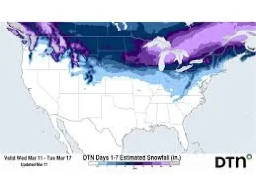
That second system should produce a wide band of heavy snow across much of the Northern Plains through the Upper Midwest and Great Lakes, with model guidance indicating a meaningful risk of 6-12 inches of snow across portions of those regions. Lake enhancement is expected to boost totals in the Upper Peninsula of Michigan, where forecasts call for enhanced amounts in the 6-12 inch range.
For some locations, overlap of the winds and snow could result in at least reduced visibility and pockets of blizzard conditions; in much of the region, the hazards will be separated with the strongest winds ahead of the heaviest snow band.
What the Forecast Means for the Upper Midwest and the Great Lakes
Across the Upper Midwest and the Great Lakes, the opening of the Great Lakes will help enhance snowfall rates where the second system and subsequent lake-effect set up. The band of moderate to heavy snow that forms on the northern side of the track will move into the Upper Midwest and then across the Great Lakes, increasing snowfall impacts for communities that already contend with seasonal snow accumulation.
Snow totals remain under evaluation by models, but guidance within the forecast discussion highlights a significant risk of seeing 6-12 inches of snow in parts of the Upper Midwest and Great Lakes region. Those amounts are most likely where lake enhancement combines with the primary snow band.
Northern Plains communities opened this piece on the season with calving and other springtime activities; after the two storm systems move through, the next confirmed development is the potential for continued lake-effect snow on March 16 (ET). That lake-effect period could extend impacts for communities along the Great Lakes shoreline into March 16 (ET).


