


Pittsburgh Tornado Warning and Philadelphia Severe Storms: What You Need to Know After Wednesday's Outbreak
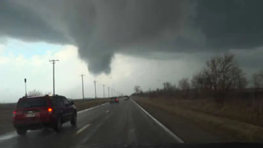
Pittsburgh dodged the worst Wednesday — barely. A tornado warning blanketed the city and surrounding communities for nearly 30 minutes early afternoon, one of three separate warnings issued across western Pennsylvania as a massive storm system churned through more than 20 states. The Pittsburgh tornado warning has since expired. The cold front has passed. Now the region faces a sharp temperature drop and the question of what Thursday and the weekend bring.
Pittsburgh Tornado Warning: What Happened Wednesday
The NWS Pittsburgh office issued a tornado warning covering Pittsburgh, West Mifflin, and Baldwin until 2:30 PM ET Wednesday, followed by a second warning for Allegheny and Washington counties. Greene County held its own separate tornado warning through mid-afternoon.
A tornado watch covered Allegheny, Fayette, Greene, Indiana, Washington, and Westmoreland counties until 8 PM ET, with the watch extending into parts of Maryland, Virginia, and West Virginia. By 11 PM, both the Tornado Watch and Flood Watch for the region had expired.
Duquesne Light reported nearly 9,000 outages at peak Wednesday afternoon, dropping to roughly 2,500 active outages by mid-evening. At Pittsburgh International Airport, more than three dozen flights were delayed and two canceled.
Philadelphia Weather Wednesday Into Thursday
The Philadelphia region took a different but still serious hit. The entire Philadelphia area was placed under a First Alert until 11 PM ET Wednesday due to severe storms carrying the chance of an isolated tornado. No confirmed tornado touchdown has been reported in the Philadelphia metro.
Rain is expected to mix with and change over to wet snowfall for Thursday, March 12 — a jarring swing after a day of severe thunderstorms. Thursday highs across western Pennsylvania will only reach the low 40s, with wind chills dropping into the 20s and 30s.
Pittsburgh Weather Forecast Through the Weekend
Friday is forecast to be the windiest day of the week as another cold front moves through, with temperatures reaching the mid-50s before dropping again. The weekend brings a milder stretch, with highs near 70 on Sunday before rain returns early next week.
The Ohio River is being watched closely. It reached 16.7 feet Wednesday morning, and the NWS issued a flood advisory through Saturday. Water begins spilling onto the Mon Wharf parking lot at 18 feet.
Wednesday Was Part of a Larger, Deadlier Outbreak
Pittsburgh's warnings did not exist in isolation. More than 180 reports of severe weather — large hail, damaging winds, and tornadoes — had already been logged before Wednesday afternoon. AccuWeather described the setup as the most widespread and impactful severe weather outbreak of the year so far. At least two people were killed earlier in the week when the same system hit Illinois and Indiana.
The Storm Prediction Center placed all of western Pennsylvania, eastern Ohio, and the West Virginia panhandle under a "slight" risk — level two on a five-point scale — meaning increased confidence in severe storms occurring, with the possibility that "a few severe storms could be significant."
Tornado Warning vs. Watch vs. Tornado Emergency — Know the Difference
These three alerts mean different things and require different responses.
A Tornado Watch means atmospheric conditions support severe thunderstorms capable of producing tornadoes — review shelter plans, charge devices, and monitor alerts closely. A Tornado Warning signals immediate danger: radar has detected rotation or a tornado has been spotted on the ground. Move immediately to a basement or interior room on the lowest floor, away from windows. A Tornado Emergency is rare, reserved for confirmed destructive tornadoes targeting populated areas, and signals catastrophic damage potential.
Residents should keep wireless emergency alerts enabled and identify safe shelter locations before the next warning is issued.
NWS Pittsburgh's damage survey teams are still in the field assessing Wednesday's storm tracks across Allegheny, Washington, and Greene counties. Final EF ratings have not been released.


