Watch Vs Warning: What Tornado Alerts Mean as Missouri Enters 2026 Season
Tornado activity is already on the 2026 calendar, and the difference between watch vs warning is becoming more than a vocabulary lesson. On March 6, a tornado with 80 mph winds briefly touched down near Iantha, Missouri, causing significant barn damage but no reported injuries. The early-season touchdown, plus questions raised after deadly tornadoes in Southwest Michigan the same day, is sharpening attention on what these alerts actually signal—and what they don’t.
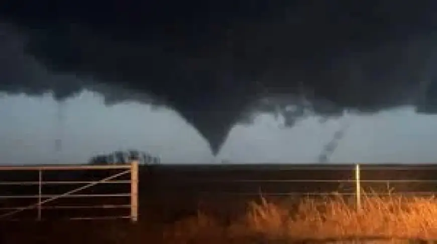
Iantha, Missouri tornado on March 6
The National Weather Service office in Springfield confirmed that a tornado with 80 mph winds briefly touched down near Iantha, Missouri, on March 6, in what may be Missouri’s first tornado of 2026. No injuries were reported. Still, the damage details underline why lead time matters: the tornado significantly damaged a barn, and roofing materials were scattered more than a mile away.
The pattern suggests that “tornado season” is less a starting gun than a window of higher odds. Even before Missouri reaches its peak months, tornado watches and warnings have already been issued this year as severe weather battered communities across the United States.
Watch Vs Warning: how alerts differ
A tornado watch means conditions are favorable for tornadoes to develop across a large region. Watches are issued by the Storm Prediction Center, described as a national forecasting center that monitors severe weather across the United States. A watch can cover multiple counties or even several states and typically lasts several hours, signaling that the atmosphere has ingredients for severe storms capable of producing tornadoes.
A tornado warning, by contrast, means a tornado is happening or about to happen. Warnings are issued by local National Weather Service offices when radar detects strong rotation within a storm or when a tornado is trained spotters, emergency managers, or the public. Warnings usually last 20 to 45 minutes and focus on specific communities in the storm’s path. When a warning is issued, immediate action is needed: move to a basement or an interior room on the lowest floor of a sturdy building and stay away from windows.
The figures point to a practical takeaway about watch vs warning: a watch describes the broader setup over hours and a wide area, while a warning is a shorter, location-specific call to shelter.
Michigan questions on missing watch
After deadly tornadoes struck Southwest Michigan on March 6, residents asked why a tornado watch wasn’t issued before the storms arrived. Michigan Governor Gretchen Whitmer has called for a review of the situation, a step that puts forecasting decisions and alert timing under scrutiny.
One key detail explains why the question can come up even when forecasters are monitoring dangerous weather: tornado watches are not issued for every storm that produces a tornado. Watches generally come when forecasters believe there is a greater chance of multiple storms producing severe weather across a broad area. If tornado potential is expected to be very isolated or uncertain, a watch may not be issued ahead of time. That means a tornado warning can be issued even when a tornado watch was never in place.
Another operational wrinkle: severe thunderstorms can sometimes produce tornadoes. A storm may first fall under a severe thunderstorm warning for damaging winds or hail. If meteorologists then detect rotation within that storm, a tornado warning may be issued for areas in the storm’s path, while the severe thunderstorm warning may remain in effect. The pattern suggests that alert types can evolve quickly as radar signatures and reports change.
Missouri’s 2026 peak timing
For Missouri, the National Weather Service says peak tornado season runs between April and June. Yet March can still produce severe thunderstorms that can form tornadoes, driven by heavy rain and temperature swings. That framing matches the calendar so far: the Iantha touchdown arrived on March 6, before the April-to-June peak.
Climatology provides another layer of context. Missouri averages just more than 30 tornadoes a year, with nearly half occurring in April and May, based on the Missouri Climate Center. Forecast expectations cited for 2026 point to a similar pattern, with tornado season expected to peak between March and May, and April potentially seeing severe weather concentrated along the Mississippi River and stretching into southwest Missouri.
Geography also matters for preparedness. Data from the National Oceanic and Atmospheric Administration indicates southwest Missouri has historically experienced the most tornadoes, followed by southeastern Missouri. Meanwhile, the Missouri State Emergency Management Agency notes that Missouri accounts for six of the 30 deadliest tornadoes in U. S. history.
For now, the open question raised by March 6 in both Missouri and Michigan is how consistently alert decisions match fast-changing storm behavior—especially in scenarios where tornado potential is isolated. If the review called for by Gretchen Whitmer identifies gaps in how watches were considered ahead of the Michigan storms, the data suggests public understanding of warning timing will remain a central part of that discussion.