


Seattle Weather turns stormy as blizzard conditions target the Cascades
Seattle weather is shifting back into a late-season storm pattern, with cool March rain in the lowlands and intensifying mountain snow set to collide with strong winds later Wednesday. The setup points to a short, active stretch through Thursday, with hazardous Cascade travel expected Wednesday night and a colder push late Friday into Saturday that could bring brief lowland snow.
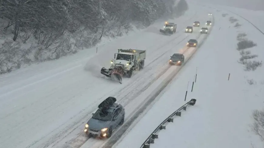
Western Washington and Stevens Pass totals set the current storm picture
Western Washington has already returned to wintry conditions over the past few days, including brief lowland snow in the North Sound on Tuesday morning. In the Cascades, fresh snowfall has piled up quickly, with nearly 3 feet reported at Stevens Pass in the past 48 hours.
For Wednesday, the lowlands are set for periods of cool March rain, keeping conditions damp for both the morning and evening commutes. High temperatures are expected to reach about 50 degrees in the metro area, described as close to normal for this time of year. In the mountains, snow is expected to intensify later Wednesday, with a winter storm warning in effect for the Cascades and an additional 1 to 2 feet of snow expected in the next 24 hours.
Seattle Weather drivers: an atmospheric river and rapidly strengthening low pressure
The primary moisture feed is described as an extended plume of moisture, known as an atmospheric river, expected to move into the Northwest tonight through Thursday. The system is characterized as oriented straight across the Pacific rather than tapping into warmer air near Hawaii, a detail tied to the expectation that snow levels should remain near pass level instead of rising significantly as they did during storms in December.
Wind becomes the dominant factor by Wednesday evening as a rapidly strengthening area of low pressure moves through Western Washington. Southerly winds of 30 to 50 mph, with gusts up to 55 mph, are expected across the region, including along the coast and through Puget Sound. The strongest winds between Kitsap and King counties are expected between 7: 00 p. m. and 11: 00 p. m. ET, and a wind advisory is in effect with gusts capable of causing tree damage and power outages.
As the storm shifts east, winds are expected to turn westerly in the Strait of Juan de Fuca and the San Juan Islands. Gusts of 40 to 55 mph are possible in places including Oak Harbor, Port Angeles, and Anacortes, adding another corridor of travel and utility risk even as the heaviest mountain impacts build.
Cascades and Olympics warnings through Thursday, then a colder push by Saturday morning
Strong winds combined with heavy mountain snow have prompted a blizzard warning for parts of the Cascades and Olympics from 6: 00 p. m. ET Wednesday to 5: 00 a. m. ET Thursday. Winds could exceed 60 mph near mountain peaks and remain strong near the passes, with travel across the Cascades expected to be hazardous Wednesday night. Through Thursday, rain in the lowlands and snow in the mountains continue even as winds ease, and snow levels are expected to hold near 2, 000 feet through Thursday and Friday.
If the midweek setup continues as described through Thursday, the visible trajectory is a two-part disruption: first, a wind-driven period Wednesday evening in Western Washington, then prolonged pass-level snowfall that keeps Cascade travel difficult overnight into early Thursday. The blizzard warning window, paired with the 1 to 2 feet of additional Cascade snowfall expected in the next 24 hours, signals that the most consequential impacts cluster around Wednesday night, even though the broader wet pattern lasts into Thursday.
Should the colder air push arrive on schedule Friday night into Saturday, snow levels are expected to drop sharply, reaching about 500 feet by Saturday morning. In that scenario, the context supports the possibility of brief, light accumulations of lowland snow, while Saturday highs are expected to struggle to rise much above the lower 40s.
The next confirmed milestone is the improvement expected Sunday and Monday, with drier weather and increasing sunshine described as arriving in time for St. Patrick’s Day, and highs that could approach 60 degrees by Monday afternoon. What the context does not resolve is where any brief, light lowland snow accumulations might be most likely by Saturday morning, beyond noting that snow levels may fall to around 500 feet.


