


High Wind Warning and Wind Advisory in Effect Across Pacific Northwest Today
A powerful Pacific storm is hammering Washington State today with warnings stretching from the coast to the Cascades. The National Weather Service has issued overlapping High Wind Warnings and Wind Advisories across the region — and tonight's conditions are expected to be significantly worse than this morning's.
Washington Faces Two-Phase Wind Event
The storm is unfolding in stages. A Wind Advisory is in effect from 3 p.m. today through 6 a.m. PT Thursday for northwest and west central Washington, including the greater Seattle metro, with southwest winds of 25 to 30 mph and gusts up to 50 mph expected.
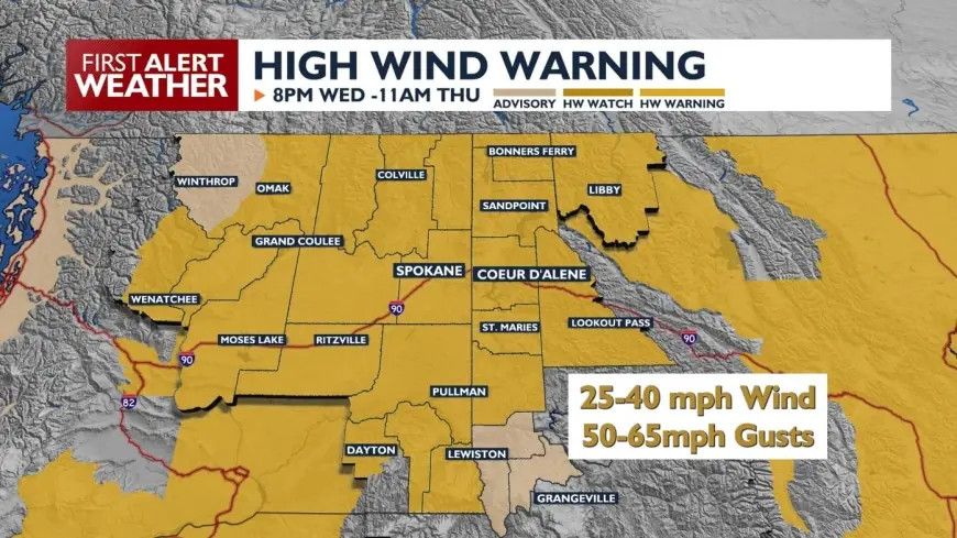
East of the Cascades, the situation escalates. A High Wind Warning is in effect from 8 p.m. Wednesday through 11 a.m. PT Thursday for the Wenatchee area, Okanogan Valley, and Central Chelan County — covering cities including Wenatchee, Cashmere, Leavenworth, Chelan, Okanogan, and Omak. Southwest winds of 20 to 30 mph with gusts up to 60 mph are expected, with mountain gusts reaching 75 mph. Widespread power outages are anticipated.
The National Weather Service in Spokane was direct in its guidance: "Remain in the lower levels of your home during the windstorm and avoid windows."
Coastal Washington and the Olympics
The Wind Advisory covers Grays Harbor County Coast and the Northern Washington Coast — including Neah Bay, Quillayute, Westport, Ocean Shores, and La Push — from 3 p.m. Wednesday through 6 a.m. Thursday. Southwesterly winds shifting to westerly, gusting up to 50 mph, are forecast along the coast.
The Strait of Juan de Fuca is under a separate, more severe designation. The National Weather Service issued a Storm Warning for the East Entrance of U.S. Waters in the Strait of Juan de Fuca, effective from 2 p.m. Wednesday through 2 a.m. Thursday. Mariners and ferry operators in the region were put on notice early this morning.
Kittitas Valley and the Simcoe Highlands: Highest Gusts
The most extreme conditions are forecast for the Kittitas Valley and Simcoe Highlands — including Ellensburg, Thorp, Goldendale, and Bickleton — where southwest winds of 30 to 40 mph with gusts up to 65 mph are expected from 8 p.m. Wednesday through 11 a.m. Thursday. Highest winds are concentrated over elevated terrain and wind-prone corridors including Highway 97 in the Simcoe Highlands and Interstate 90 east of Ellensburg.
High-profile vehicles — semi-trucks, RVs, trailers — face the greatest risk on those corridors. The National Weather Service flagged travel as "difficult" throughout the warning period.
Mountain Snowstorm Compounds the Threat
The wind event doesn't arrive alone. A Blizzard Warning is in effect from 6 p.m. Wednesday through 5 a.m. Thursday for the Cascades of Snohomish, Northern King, Whatcom, and Skagit counties, with total snow accumulations up to 13 inches and gusts reaching 55 mph. Visibilities may drop below a quarter mile due to blowing snow, and travel is restricted to emergencies only in those zones.
A Winter Storm Watch extends from late Wednesday night through late Friday night for the Cascades of Pierce, Lewis, and Southern King counties, with 1 to 4 feet of snow possible and gusts up to 40 mph.
Oklahoma Red Flag Warning Also Active
The Pacific Northwest isn't alone. A Wind Advisory and Red Flag Warning are in effect across southwest Oklahoma through early Wednesday evening, with windy conditions, cooler temperatures, and mostly sunny skies creating dangerous fire weather conditions in the Lawton area.
The National Weather Service's guidance applies across all active zones: secure outdoor objects, charge essential devices now in anticipation of outages, and identify an interior shelter room before conditions peak tonight. Wind gusts of 50 to 65 mph are possible in eastern Washington, with the potential for widespread tree damage, power outages, choppy lakes, and blowing dust near the Moses Lake area.


