


National Weather Service Warns of New Severe Storm Threat After Deadly Midwest Tornadoes
The National Weather Service warned Wednesday that another round of severe thunderstorms could sweep from the Ohio Valley into parts of the East and Deep South after tornadoes and destructive hail hit the Midwest, leaving at least two people dead in Indiana and causing extensive damage in Illinois and surrounding areas. The agency’s latest forecast packages and local briefings point to damaging winds, large hail and isolated tornadoes as the main concerns as the storm system pushes east.
Deadly Storms Put the Focus on Fresh Warnings
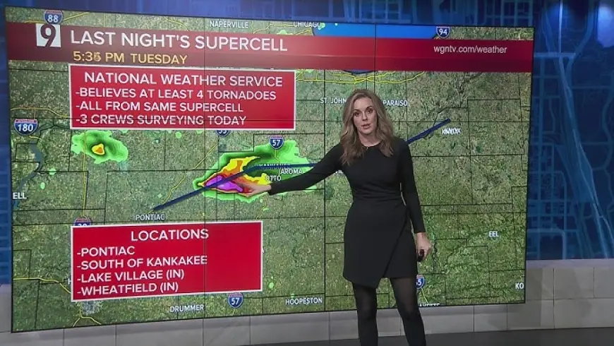
The sharpest urgency around the National Weather Service on Wednesday came after Tuesday’s storms turned deadly in northern Indiana. A tornado destroyed a home in Newton County, killing an elderly couple, while additional twisters and giant hail were documented across eastern Illinois and northwestern Indiana.
That earlier damage has raised the stakes for the next phase of the outbreak. Rather than a one-off event, forecasters are treating Wednesday as a continuation of a broader severe-weather pattern that has already produced tornadoes, downed power lines and major structural damage across several states.
The agency’s warnings and local decision-support briefings stressed that conditions could change quickly over the course of the day, especially where fast-moving thunderstorm lines develop.
What the National Weather Service Is Warning About Wednesday
On Wednesday morning, National Weather Service offices across parts of Indiana, Ohio and Kentucky highlighted a corridor of strong to severe storms capable of producing wind gusts around 60 mph or higher, pockets of hail and brief tornado spin-ups. In some areas, the storms were expected to move at highway speeds, reducing the time people have to react once a warning is issued.
That speed is one of the biggest hazards in this setup. A severe thunderstorm warning can become immediately dangerous when a storm line is moving quickly enough to knock down trees, damage roofs and disrupt travel within minutes. In the Ohio Valley, the timing also overlapped with school and work travel, increasing the potential for widespread disruptions.
Local briefings also flagged uncertainty tied to storm evolution. Morning thunderstorms can sometimes limit later instability, but they can also leave behind boundaries that help new storms intensify later in the day. That means the precise placement of the highest risk may continue to shift even as the broader threat remains in place.
Why the Forecast Extends Beyond the Midwest
The National Weather Service is not just focused on storm cleanup in the Midwest. Forecast offices farther east and south have been preparing for the same system to arrive in stages through Wednesday afternoon and Wednesday night.
In the Ohio Valley and parts of the Mid-Atlantic, the main concern is a line of storms capable of damaging straight-line winds with isolated embedded tornadoes. Farther south, including parts of Alabama and Mississippi, forecasters warned that evening and overnight storms could become more dangerous if discrete cells form ahead of the main line.
That distinction matters. A solid squall line often brings widespread wind damage, while isolated storms can raise the tornado risk in a more concentrated way. The overall setup suggests the danger will shift geographically rather than end quickly.
How Warnings Are Being Framed for the Public
National Weather Service messaging on Wednesday emphasized a familiar but critical point: warnings are issued for storms that are imminent or already occurring, not for distant possibilities. In practical terms, that means residents under a warning should already be moving indoors, away from windows, and preparing for power loss or debris.
Emergency planners often stress three immediate actions during severe-weather days like this:
-
Have more than one way to receive warnings
-
Move to an interior room on the lowest floor if a warning is issued
-
Avoid travel during the strongest storms when possible
Those reminders become especially important when storms are expected after dark. Overnight severe weather is typically harder for residents to monitor, and fast-moving lines can arrive before people realize conditions have worsened.
A Stress Test for Forecasting and Response
The current outbreak also puts renewed attention on the National Weather Service’s central role during high-impact weather. Its local forecast offices are responsible not only for public forecasts and warnings, but also for direct coordination with emergency managers, schools, utilities and transportation agencies.
When a system stretches from the Plains to the East Coast over multiple days, that coordination becomes just as important as the forecast itself. Communities need lead time to open shelters, stage repair crews, adjust school operations and prepare for flooding or extended outages after the storms pass.
Wednesday’s weather will not look the same in every state, and not every warned area will see the worst-case outcome. But after deadly tornadoes, giant hail and severe damage in the Midwest, the National Weather Service is making clear that this is still an active and dangerous event, with the next round of hazardous storms already moving into place.


