


Kankakee Tornado in Illinois and Lake Village, Indiana, Leaves Deadly Damage as Weather Threat Shifts East
A powerful storm that tore across Kankakee County, Illinois, and into Lake Village, Indiana, left a trail of destroyed homes, shattered infrastructure and at least two deaths, turning a night of severe weather into a recovery effort by Wednesday morning.
The same supercell that crossed Kankakee also produced unusually large hail, including a 6-inch stone reported in the Illinois city, while forecasters warned that the broader severe-weather threat had not ended for the region.
What Happened in Kankakee and Lake Village
The storm moved through Kankakee County on Tuesday evening, producing tornado reports near the Kankakee Airport, Aroma Park, Hopkins Park and areas farther east toward the Indiana state line. The National Weather Service logged a tornado touchdown near Kankakee Airport at about 7:24 p.m. ET, with additional tornado reports continuing east through the county over the next half hour.
As the storm crossed into northwest Indiana, damage intensified around Lake Village in Newton County. Homes were leveled, utility poles were snapped and emergency crews worked through the night in debris-strewn neighborhoods. Authorities in Indiana said two people were killed after the tornado struck the Lake Village area, making it the deadliest part of the storm’s path.
By Wednesday morning, officials were still assessing injuries and the full extent of structural damage.
Why This Storm Stands Out
This was not an isolated brief touchdown. Meteorologists described the system as a long-track supercell that remained dangerous as it moved from Illinois into Indiana. That helped explain why communities in multiple counties reported tornado damage, broken power lines, damaged businesses and blocked roads from the same storm complex.
Kankakee also saw giant hail alongside the tornado threat. The National Weather Service said a hailstone measured at 6 inches in diameter in the city Tuesday evening, a size that could challenge the Illinois state record if confirmed. Reports elsewhere in and around Kankakee included hail from roughly 2 to more than 5 inches wide, enough to smash windows, damage roofs and cripple vehicles.
That combination of tornadoes and giant hail made the storm especially destructive even before it reached Indiana.
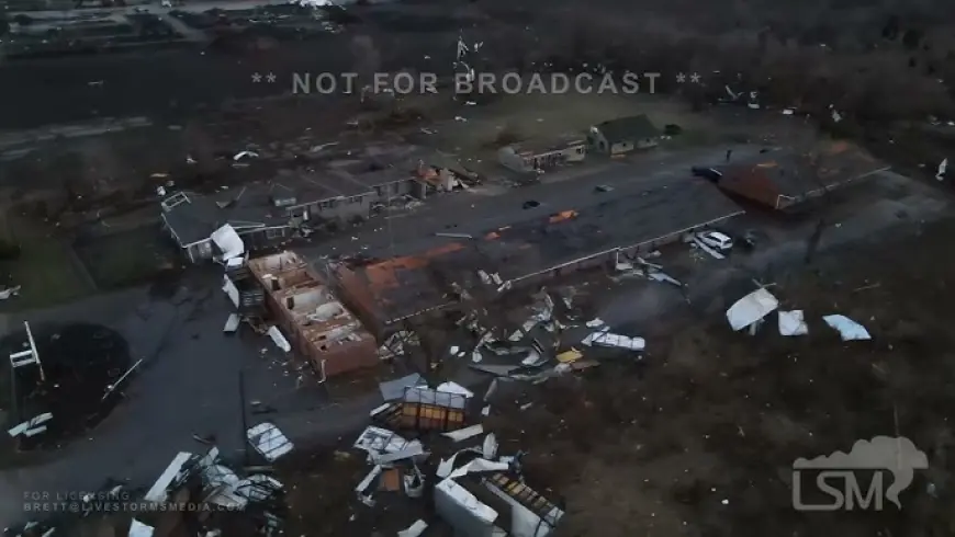
Damage Across Kankakee County
In Kankakee and nearby communities, the storm damaged buildings, tore apart trees and disrupted power. Local reports placed damage near industrial areas by the airport, with additional destruction around Aroma Park and south of Sun River Terrace.
The weather service’s preliminary event summary showed how quickly the storm escalated. Hail reports in Bradley and Kankakee were followed within minutes by tornado sightings and damage reports along the storm’s northeast track. Residents posted images of broken roofs, downed poles, battered vehicles and scattered debris as the cell moved through.
Even where no major injuries were immediately reported in Illinois, the storm left behind the kind of damage footprint that often requires lengthy cleanup and insurance assessments.
The Tornado Watch and Wednesday Weather Outlook
By early Wednesday, the immediate severe threat for Kankakee County and northwest Indiana had eased. The Chicago-area forecast office said no severe weather was expected locally, with only isolated thunderstorms possible south of Interstate 80 during the morning.
The broader system, however, was still active farther east. A tornado watch remained in effect into midday Wednesday for a large part of Indiana and Ohio as the storm threat shifted away from the Kankakee-Lake Village corridor. That meant the communities hit Tuesday night were moving into recovery mode even as other parts of the Midwest and Ohio Valley remained under alert.
For residents in hard-hit areas, the change in forecast offered only limited relief. Downed lines, unstable structures and debris fields remained immediate hazards after sunrise.
What Comes Next
Damage surveys are expected to clarify how many tornadoes touched down and how strong they were. Early reports indicate multiple tornado tracks may have been involved, but final ratings and path details will depend on on-the-ground inspections.
The recovery effort is likely to focus first on search operations, debris removal, power restoration and temporary shelter for displaced residents. Officials have also urged people to stay away from the worst-hit neighborhoods unless they live there or are part of emergency response.
For Kankakee, Lake Village and surrounding communities, the next phase is no longer about forecasting the storm’s arrival. It is about measuring what it changed in a matter of minutes and how quickly those towns can begin to rebuild.


