


Weather Forecast: Two March 11 outlooks highlight storm timing and temperature gaps
The March 11 weather forecast coverage splits into two sharply different pictures: one centered on showers and a few thunderstorms moving through Middle Tennessee and Southern Kentucky, and another describing a soggy start that turns much colder with snow or sleet possible later. Putting them side by side answers a practical question for commuters and planners: is today mainly about storm risk, or about a rapid shift into winter-like conditions?
Middle Tennessee and Southern Kentucky: SPC Slight Risk and earlier storm timing
One outlook for March 11 begins with morning clouds, showers, and a few thunderstorms, with none anticipated to be severe at the start of the day. It also frames the day around timing: the system is expected to arrive a little earlier, which is described as “great news” because a faster-moving setup can limit how long sunshine has to fuel instability. In that view, storms are expected to move in late morning to around noon to the northwest, then track eastward.
Risk is still part of the picture. The Storm Prediction Center places all of Middle Tennessee and Southern Kentucky under a Slight Risk (2 out of 5). The expectation is not for a widespread severe event, yet the forecast still calls for a handful of severe storms. The stated main concerns are damaging wind gusts, straight-line winds, and localized flooding, while the hail and tornado threat is described as low but not zero.
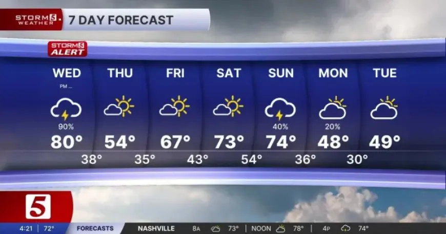
That same outlook attaches specific temperature markers to the day and the days that follow: a high of 79 with southwest winds at 5–15, then a mostly cloudy night with storms moving out and a low of 67 with south-southwest winds at 5–15. It also signals a cooler shift for Thursday, with highs in the mid-50s, and flags another cold front Sunday evening that could lead to morning lows in the upper 20s to low 30s early next week.
Morning Drive Forecast: heavy rain, flooding impacts, and snow or sleet later
A second March 11 outlook also starts wet, describing a soggy morning with more rain and thunderstorms and stating that the day’s thunderstorms are not expected to be severe. The emphasis, however, is less about instability and more about impacts already showing up on the ground: heavy rain and lightning continue, and flooding has been occurring since last night’s storms. With additional rain, it warns that standing water or flooded roads may linger “for a while. ”
The time evolution differs, too. In this version, rain is heaviest in the morning, then slowly becomes light rain in the afternoon. Temperature guidance is framed as a steep drop through the day: highs in the upper 50s in the morning, but “plan for a much colder day, ” with afternoon temperatures only in the 30s. It adds that some snow or sleet may even appear later today.
Beyond March 11, that same outlook stays locked on cold-weather precipitation: tonight is described as cold with a few light snow showers and lows dropping to 28. Thursday turns “chilly” but includes some sunshine and mostly sunny skies with highs near 43, followed by another chance of rain or a rain/snow mix Thursday night into Friday. Friday is described as featuring rain and snow for the first half of the day, Saturday as cloudy with a few light snow showers, and Sunday as more rain during the day and snow by Sunday night. It also raises the possibility of accumulating snow early next week.
Weather Forecast comparison: same non-severe baseline, different primary hazard
Set next to each other, the two March 11 narratives share a common starting point but diverge in what they treat as the day’s defining risk. Both state that the day’s thunderstorms are not expected to be severe. Yet one forecast focuses on the potential for a “handful of severe storms” within a Slight Risk (2 out of 5) area, prioritizing damaging wind gusts, straight-line winds, and localized flooding while keeping hail and tornado potential low but not zero. The other focuses on heavy rain, lightning, and ongoing flooding impacts from last night, then pivots quickly to cold: afternoon temperatures in the 30s, with snow or sleet possible later.
| Comparison point | Middle Tennessee/Southern Kentucky outlook | Morning Drive outlook |
|---|---|---|
| Thunderstorm severity expectation | Morning storms not anticipated to be severe; a handful of severe storms possible later | Today’s thunderstorms not expected to be severe |
| Primary impacts highlighted | Damaging wind gusts, straight-line winds, localized flooding; hail/tornado low but not zero | Heavy rain, lightning, standing water/flooded roads; wintry mix later |
| Timing emphasis | System a little earlier; storms late morning/noon northwest, then eastward | Heaviest rain in the morning; light rain in the afternoon; snow/sleet later today |
| Temperature framing | High 79; low 67; cooler Thursday in the mid-50s | Upper 50s in the morning; 30s in the afternoon; low 28 tonight; high near 43 Thursday |
| Next-week signal | Cold front Sunday evening; morning lows upper 20s to low 30s next week | Snow by Sunday night; accumulating snow possible early next week |
Analysis: The comparison establishes that March 11 planning hinges on which risk dominates locally: in one area the key concern is a short window for stronger storms within a Slight Risk, while in the other the bigger story is heavy rain and flood-prone roads followed by a turn toward snow or sleet as temperatures drop. The next confirmed checkpoints that will test this split are late morning to around noon, when one outlook expects storms to move in from the northwest, and later today, when the other outlook says snow or sleet may develop. If the earlier timing holds and clouds linger as expected, the comparison suggests the severe threat stays limited; if heavy rain persists into the colder afternoon, the travel impacts shift toward standing water first and wintry precipitation later.


