


South Bend Weather: Tornado watch and late-night storms point to a wet, cooler stretch
south bend weather is turning volatile Tuesday night, with a tornado watch issued for all of Michiana until 2: 00 am ET Wednesday. The setup signals a two-part threat: storms that can turn severe during the evening, followed by a broader push of rain and storms into early Wednesday, and then a cooler pattern with daily rain chances later in the week.
Michiana tornado watch until 2: 00 am ET and a late-Tuesday severe window
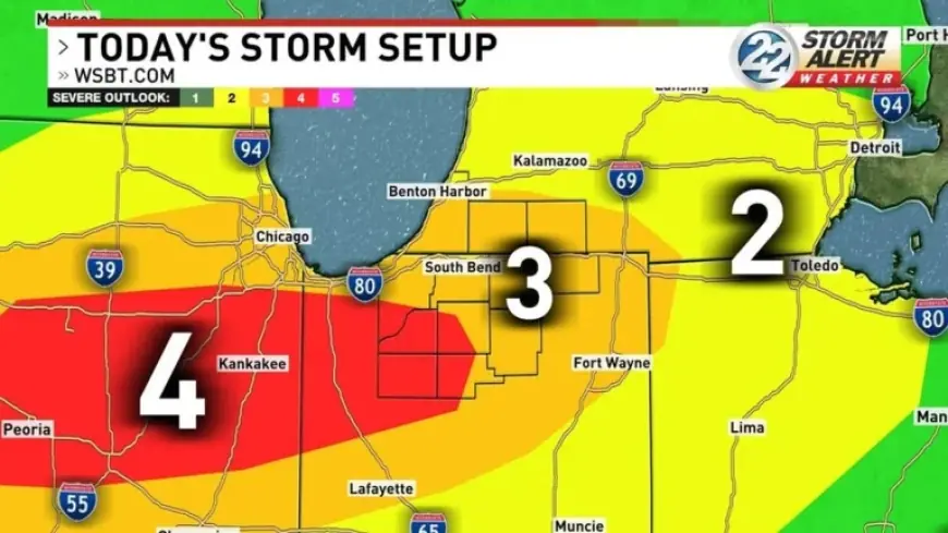
A tornado watch is in effect across all of Michiana until 2: 00 am ET Wednesday, as severe weather is expected late Tuesday. The Storm Prediction Center has highlighted Michiana for widespread severe weather, placing southern and western communities in a Level 4 risk (Moderate Risk) while the rest of the area is under a Level 3 risk (Enhanced Risk).
Timing cues in the forecast point to storms arriving in stages. Some storms could develop along and ahead of a warm front as early as 6: 00 pm ET, and those storms are expected to be more cellular in nature. Chances for widespread rain and storms increase later in the night, around 10: 00 pm ET and later, before a line of storms arrives early Wednesday morning.
Primary hazards highlighted for the late Tuesday into early Wednesday period include tornadoes and large hail, with damaging winds and heavy rain also in play as the line of storms arrives. The weather setup includes warm and humid conditions ahead of the storms, with the warmest spots reaching highs in the upper 60s to low 70s.
Chicago-area damage reports and watches add regional signals for northwest Indiana
Regional storm impacts have already been evident around Chicago Tuesday afternoon and evening, where strong storms swept through the area and caused damage. In Kankakee County, officials described extensive damage in Aroma Park and said there were some minor injuries, while police said wires were down throughout the county and motorists should use caution. A closure was reported on Route 45/52 from River Road to Exit 308 of Interstate 57 due to downed power lines, storm damage, and fires, and there was also flooding reported in Kankakee.
Even as tornado warnings in parts of the area expired, watches and warnings remained active across nearby counties. A Severe Thunderstorm Warning was issued for LaPorte County until 9: 30 pm ET. A Tornado Watch covered multiple counties in Illinois and Indiana until 11: 00 pm ET, and a Severe Thunderstorm Watch extended across additional counties into midnight Wednesday.
Those reports matter for Michiana because they show storms capable of producing damage and disruptions within the broader region while a tornado watch is posted for all of Michiana until 2: 00 am ET Wednesday. Another disruption indicator appeared in aviation: a ground delay was in effect at O’Hare airport, and a ground stop was in effect at Midway until about 9: 00 pm ET, with dozens of flights canceled at both airports.
South Bend Weather trends: heavier rain totals, localized flooding, and a turn cooler
After the late-night severe threat, the forecast emphasizes an expanding rain footprint and cooling temperatures. Several inches of precipitation are expected across the area, and rain totals are likely to exceed 1–2 inches for many on Wednesday, raising localized flooding concerns and the possibility of localized flash flooding. Rain and storms are expected to carry into early Wednesday morning, and widespread rain is expected Wednesday.
Temperature changes mark the next phase. Highs in the upper 50s are expected to be reached very early Wednesday morning, then colder air filters in behind the passing cold front. Much of Wednesday is expected to be spent in the 40s, and highs are expected to be in the 40s and 50s the rest of the week and into the weekend. That cooler stretch also comes with daily chances of rain, and there is even mention of some snowflakes mixing in.
If the late-night storm timing continues as outlined… the key signal for south bend weather is a progression from early, more cellular storms around 6: 00 pm ET to more widespread rain and storms after about 10: 00 pm ET, followed by a line of storms early Wednesday morning. Under that trajectory, the primary concerns stay centered on tornadoes and large hail during the severe window, then shift toward damaging winds, heavy rain, and localized flooding as rain totals build into Wednesday.
Should the heavy-rain forecast verify at the higher end described… localized flooding and localized flash flooding would become the defining impact on Wednesday, especially with totals likely exceeding 1–2 inches for many and several inches anticipated across the area. In that scenario, the storm story would move quickly from the tornado watch period into rain-driven hazards as widespread rain persists through Wednesday.
The next confirmed milestone is the tornado watch expiration time of 2: 00 am ET Wednesday, with the forecast also flagging a line of storms arriving early Wednesday morning and widespread rain through the day. What the context does not resolve is where the most intense impacts will concentrate inside Michiana, even as the area is split between Level 4 and Level 3 risk zones and the primary hazards include tornadoes and large hail.


