


Kilauea episode 43 escalation signals a more disruptive phase for Halemaumau
kilauea entered episode 43 of its ongoing summit eruption Tuesday morning, with USGS observations showing tephra falling and lava activity at vents within Halemaumau. The episode’s early signals point toward a trajectory of wider, harder-to-predict impacts, as light and variable winds raise the likelihood that volcanic gas emissions and volcanic material will distribute unevenly beyond Hawaiʻi Volcanoes National Park.
USGS and Hawaiian Volcano Observatory track episode 43 beginning at 9: 17 a. m. HST
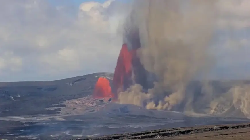
Episode 43 began at 9: 17 a. m. HST on March 10, 2026, when volcanic tremor doubled and tilt accelerated downward, with precursory lava flows beginning about an hour earlier. Later Tuesday morning, the Observatory described how ground-level sensors near the eruptive vents indicated light and variable winds, a combination that can push volcanic gas emissions and volcanic material in shifting directions from Halemaumau.
Just before 10 a. m., the Observatory noted that north vent fountains were just over 300 feet (100 meters) high, with a plume rising vertically and falling tephra observed near a camera north of the vents. A newly installed microphone attached to that camera was also picking up the sound of raining material. The south vent began overflowing lava just before 10 a. m., adding another active element to the episode’s early phase.
Separate official descriptions emphasized the size and reach of falling material. Football-sized particles were described as being launched into the air, and large volcanic pieces were reported at overlooks in Hawaiʻi Volcanoes National Park. Taken together with the webcam and sensor observations, the episode began with multiple indicators of vigorous activity at the summit vents and immediate hazards close to visitor areas.
Kilauea alert levels and Hawaiʻi County Civil Defense actions highlight expanding hazard zones
A key signal of where the situation stands came in an 11: 15 a. m. update: the USGS Volcano Alert Level for Kīlauea was raised from WATCH to WARNING, and the Aviation Color Code raised from ORANGE to RED. The stated driver for that escalation was voluminous tephra spreading to the north, including impacts described on golf course housing and Highway 11, where tephra was said to be up to 5 inches.
Hawaiʻi County Civil Defense also described direct operational consequences on the ground. Highway 11 was closed between the 24 and 40 mile markers due to dangerous conditions that included tephra falling on the roadway. The public guidance emphasized health and exposure risks from volcanic gases and the physical hazards of tephra, advising sensitive individuals to shelter indoors or leave the area, to minimize exposure to glass particles and larger tephra, and to disconnect water tank connections from gutters to limit contamination from tephra.
For aviation, the episode arrived alongside a communications change intended to improve how hazard information moves through the system. The USGS Hawaiian Volcano Observatory issued a reformatted Volcano Observatory Notice for Aviation (VONA), described as a notification product used globally to inform the aviation community of volcanic activity that could pose a hazard. The formatting change was presented as a way to improve how the aviation community receives these messages, a practical adjustment that becomes more consequential when the Aviation Color Code is elevated.
Halemaumau wind variability and tephra spread point to uneven impacts north and east
The most consistent directional signal in the context is the combination of light, variable winds and observed tephra spread. Sensors near the vents suggested distribution from Halemaumau could be unpredictable, while the 11: 15 a. m. update described tephra spreading north, and the Observatory noted tephra could fall around the summit and into communities to the north and east of Hawaiʻi Volcanoes National Park. That mix points toward a near-term pattern where the footprint of impacts may shift within a broad arc, instead of staying confined to a single downwind corridor.
Another trajectory marker comes from the eruption’s episodic structure. A reference map posted on March 2, 2026 described the Kīlauea summit eruption within Halemaumau crater as having begun on December 23, 2024, and said that as of March 2 the eruption had had forty-two episodes, with the most recent occurring on February 15. Episode 43 beginning on March 10 establishes a continuation of that episodic cadence, while the early tephra and vent activity show that individual episodes can still produce immediate hazards to roads, overlooks, and nearby housing areas.
- Based on context data: March 2, 2026 posting: 42 episodes through episode 42; most recent episode then was February 15.
- Based on context data: March 10, 2026: episode 43 began at 9: 17 a. m. HST; by late morning, alerts escalated to WARNING and RED.
- Based on context data: March 10, 2026: Highway 11 closure between the 24 and 40 mile markers due to tephra on the roadway.
If the episode 43 tephra pattern continues… the most immediate trajectory suggested by the context is further interruptions tied to where tephra falls, because the winds were described as light and variable and the tephra was already spreading north. Under that condition, closures and shelter guidance could remain central tools, especially where tephra is described as accumulating on highways and affecting housing areas.
Should the incoming storm concern materialize… the context flags a specific additional pathway for impact: concern that an incoming storm could send ash onto homes near the volcano. That scenario is not presented as a certainty, but it does establish a conditional risk that could widen household-level exposure beyond areas already seeing falling material near the park and Highway 11.
The next confirmed signal in the context is procedural as well as volcanic: officials indicated the episode would be updated as it progresses, while the upgraded USGS Volcano Alert Level and Aviation Color Code mark a higher operational posture. What the context does not resolve is how long episode 43 will persist, or whether tephra distribution will concentrate in one direction versus continuing to shift with the light and variable winds. For now, kilauea’s episode 43 is defined by active vent behavior at Halemaumau and rapidly escalating responses where tephra and gases intersect with roads, housing, and aviation hazards.


