


Severe Weather Outlook: A warm, wet week tests Central and South Alabama’s routines
By mid-afternoon in Montgomery, Ala., the air feels more like spring than late winter, heavy and damp as showers build again. The severe weather outlook for Central and South Alabama is defined by repetition this week: rounds of storms that grow more numerous through the afternoon and evening, then taper overnight—only to return as a stronger system approaches Wednesday.
What is the Severe Weather Outlook for Central and South Alabama this week?
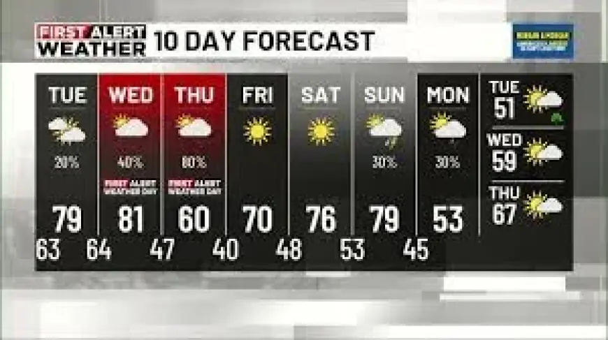
The region is locked into a warm, wet pattern that lasts through Wednesday, followed by a brief cool-down on Thursday as a strong cold front moves through Wednesday night into Thursday morning. Showers and thunderstorms are expected to develop and become more numerous through the afternoon and evening, and some storms could become strong to severe. The main threats highlighted are damaging wind gusts and large hail.
Later in the week, a strong storm system is expected to move into Central and South Alabama during the afternoon and evening hours. A line of storms is expected to develop and move across the region, bringing heavy rain, frequent lightning, strong winds, and the potential for a few tornadoes. The tornado risk is described as low at this time, but not zero. This system is framed as the most significant weather threat of the week.
When will conditions improve, and what days look best for plans?
Tuesday is described as a better day for outdoor plans: mostly cloudy with only a slight chance of showers, mainly across northern portions of the area. For people trying to fit in errands, practices, or work that depends on dry stretches, Tuesday is positioned as the week’s most workable window.
Conditions shift again late Wednesday into Thursday morning as the cold front arrives. Thursday starts with a chance of showers early, then gradually improves. Temperatures are expected to drop noticeably, with highs only reaching the low 60s as cooler air moves in behind the front—after warmer readings ahead of the system. The cool-down is expected to be brief: Friday clears with sunny skies and highs in the low 70s, with warming continuing into the weekend into the upper 70s. Early next week turns quieter with mostly sunny skies, highs in the 60s and 70s, and lows falling into the 40s and low 50s.
What hazards are highlighted, and what should residents do now?
This week’s hazards are tied to timing and intensity. As storms become more numerous through afternoon and evening hours, a few could be strong to severe, especially during early evening. The stated primary threats are damaging wind gusts and large hail. With the stronger system expected later, impacts broaden to heavy rain, frequent lightning, and strong winds, alongside a low-but-nonzero tornado potential.
The practical guidance offered is straightforward: remain weather-aware and have multiple ways to receive weather alerts. That includes keeping a weather app handy for updates, using live radar and hourly information, and relying on push alerts when storms approach. The focus is on readiness rather than alarm—recognizing that the pattern is active and changeable, and that the most significant threat arrives with the stronger midweek system.
In the end, the severe weather outlook is less about one dramatic moment than the accumulation of decisions—whether to wait out the afternoon storms, use Tuesday’s relative calm, or prepare for the stronger line expected to cross the region. In Montgomery’s sticky air, the week asks residents to keep adjusting, one round at a time, until the front finally nudges conditions toward a brief, cooler break.


