


San Antonio Weather: Cold Front Brings Hail, Flood Threat and a Wet Stretch
The region faces a wet and unsettled period as a southeast-moving cold front teams with a slow upper-level low to produce showers and thunderstorms from this afternoon through the middle of next week. San Antonio Weather observers should be prepared for rounds of rain, isolated severe storms, and a heightened flood threat in parts of the area.
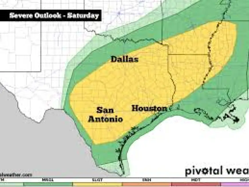
Cold front timing and severe threats
The front is moving southeast out of north Texas and is expected to pass Central Texas between noon and 6: 00 this afternoon, triggering an increasing chance of thunderstorms late this morning into the afternoon. Present threat assessments place the entire coverage area at a 2 out of 5 risk for severe weather, with large hail and damaging wind gusts identified as the primary hazards. Hail could reach up to 2 inches in diameter.
Overnight thunderstorms ahead of the front have so far been non‑severe, but additional rounds of rain are forecast to continue overnight Saturday into early Sunday morning. The severe potential will diminish after the cold front moves through, but isolated strong storms could still occur tonight and into Sunday as the system evolves.
Weather Prediction Center flood outlook and localized impacts
The Weather Prediction Center has updated the flood threat tied to the event. Most of the region is at a level 1 flood threat for today, while eastern portions of Lee, Fayette, and Milam counties are designated at level 2. Those levels indicate an elevated chance of locally heavy rainfall capable of producing urban and small-stream flooding in vulnerable locations.
Forecasts call for occasional showers and thunderstorms to persist through Wednesday because a cut-off upper-level low over the eastern Pacific—positioned east of the northern Baja Peninsula—will drift slowly and continue channeling Pacific moisture into the area for the next four-plus days. That slow movement is a key factor: what makes this notable is that a stalled, moisture-rich low can prolong periods of heavy rain and increase the cumulative rainfall that drives flooding concerns.
Short-term forecast and next-week hazards
Forecasters expect a few showers and thunderstorms this evening, with isolated light rain overnight. Rain and storms are expected to ramp up again Saturday and into Sunday due to the lingering upper low. Rain chances decrease Sunday night into Monday, but models project the upper-level low will shift eastward toward El Paso by Tuesday afternoon. There it is forecast to interact with another cold front, raising the chance of additional showers and thunderstorms on Tuesday and especially Tuesday night, with a renewed threat for severe weather.
After that window, only a few lingering showers are expected on Wednesday before a break: dry and brighter conditions are forecast to return Thursday through the following Saturday. Residents are advised to monitor conditions through the weekend as storms develop and move through.
Practical steps for households
With multiple rounds of rain and pockets of severe weather possible, simple preparedness can reduce risk. Check that storm drains and gutters are clear where flooding is a concern, and secure loose outdoor items ahead of gusty winds. Tonight is also the scheduled change to Daylight Saving Time; clocks should be set ahead one hour tomorrow, and it is a recommended time to install fresh batteries in smoke and carbon monoxide detectors.
The combination of a southeast-moving cold front and a slow, moisture-bearing upper-level low creates a defined chain of cause and effect: the front will initiate the initial surge of storms, while the parked low will sustain moisture inflow and the potential for repeated rounds of heavy rain. That interplay drives the region's elevated hail, wind, and flood threats through the next several days.