


Weather Chicago: Severe storms, hail and fog threaten travel as ground stops hit O'Hare and Midway
Weather Chicago faces a multi-wave threat Friday into Saturday that could bring hail, gusty winds and dense fog, with ground stops at major airports and multiple rounds of showers and thunderstorms expected. The combination of hazardous travel conditions and a high-profile public event in the city raises stakes for commuters and visitors.
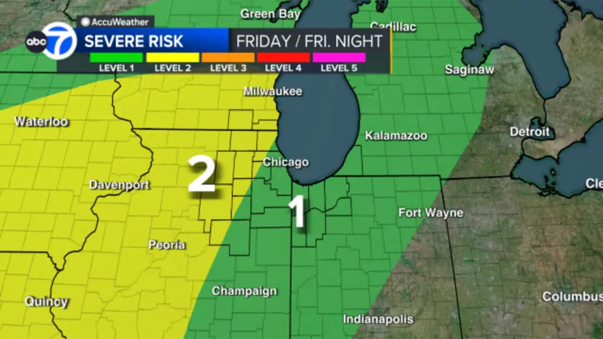
Weather Chicago: immediate hazards and who is at risk
A cluster of showers and thunderstorms is likely to move through the Chicago area during the morning hours Friday. That cluster presents a relatively low overall threat of severe weather but could produce hail and gusty winds. Isolated thunderstorms may occur during Friday afternoon and evening, with potential for high winds, hail and a low-end tornado threat in some areas.
- Primary short-term threats: hail and gusty winds from morning clusters and scattered cells later in the day.
- Risk levels: much of the metro area is under a Level 1 severe threat, while some south, west and north suburbs are under a Level 2 risk.
- Overnight into Saturday: a scattering of showers and thunderstorms before 8 a. m. could also become severe, with high wind identified as the biggest concern.
Airport disruptions and commute impacts
Fog and thunderstorms prompted ground stops at the region's major airports on Friday morning. A ground stop at O'Hare Airport began around 8 a. m. and remained in effect until it was replaced by a ground delay at 9: 30 a. m.; average delays were reported at 167 minutes at that airport. Midway experienced a ground stop beginning around 9: 12 a. m. that was set to expire at 10: 30 a. m. In the preceding 24 hours, 76 flights were canceled at O'Hare and 20 at Midway, increasing pressure on both air travel and surface transportation.
Visibility concerns compound storm impacts: a foggy morning, especially near Lake Michigan, drove visibility down to a quarter mile or less in places, creating a hazardous commute and contributing to the airport ground stops.
Storm timeline: tracking showers and storms in Chicagoland
Chicagoland is expected to experience several rounds of precipitation and storms across the day. The first round arrived in the morning rush and may create a hazardous commute. After an initial wave, there could be a brief lull, followed by additional development in the mid to late afternoon. A final round of scattered showers and thunderstorms is possible overnight along a cold frontal passage.
| Phase | Timing | Key threats |
|---|---|---|
| Morning cluster | Morning rush | Hail, gusty winds, hazardous commute |
| Afternoon/early evening | Mid to late afternoon | Strong to severe storms possible, wind and hail |
| Overnight into Saturday | Before 8 a. m. | Scattered storms with potential for severe cells; high wind primary concern |
Temperatures are expected to fall through the day behind a gusty cold frontal passage, reversing the usual diurnal rise and concentrating the most intense activity earlier rather than later. Dense fog advisories remain in effect through 10 a. m. for large parts of the metro area, but the fog should clear as storms move in.
What to watch and next steps
Residents and travelers should plan for disrupted commutes and potential flight delays or cancellations. Monitor local updates for changing storm trends and airport status; details may evolve as the situation develops. The first day of major funeral services in the city is taking place Friday, with high-profile dignitaries expected, which could increase travel volume and complicate logistics amid the weather threat.
Storm impacts are expected to be uneven across the region. Those in south, west and north suburbs where the Level 2 risk applies should be especially prepared for stronger conditions. Remain alert for local advisories and allow extra time for travel.