


Twin Tropical Lows Flood NT and North Queensland with Torrential Rain
Twin tropical lows are currently unleashing torrential rainfall across northern Queensland and the Northern Territory. This severe weather situation has led to significant flooding, particularly in Katherine, where the Katherine River has reached dangerous levels.
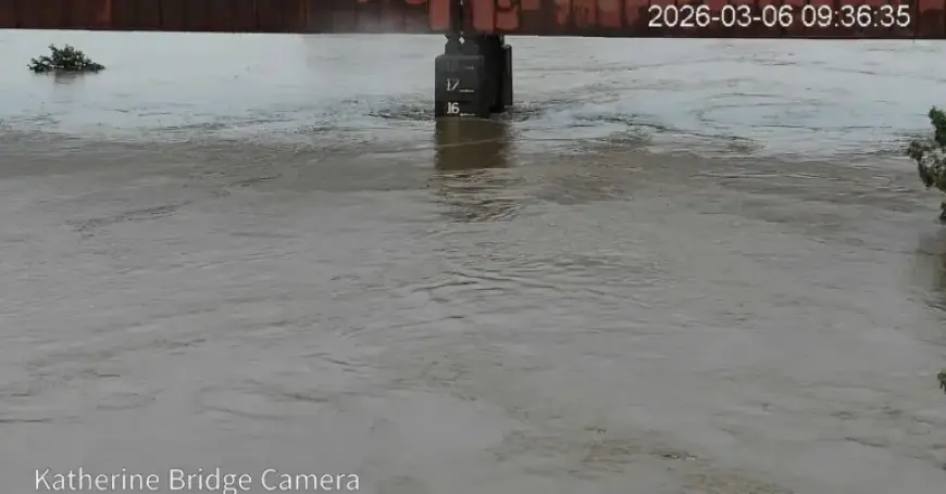
Torrential Rain and Flooding in Katherine
Katherine, located approximately 300 kilometers south of Darwin, faces its most severe flood event in decades. The Bureau of Meteorology reported that the Katherine River reached 16.75 meters earlier today, approaching the major flood level of 17.5 meters.
- Current River Level: 16.75 meters
- Expected Peak River Level: 17.5 meters
- Historical Reference: Near March 2000 flood levels
As a precaution, Katherine Hospital has evacuated all patients to facilities in Darwin. The Bureau has warned residents that additional rainfall is anticipated, which could elevate river levels even further.
Impact on Northern Territory and Major Flood Warnings
The heavy rain from these twin tropical lows is not limited to Katherine. A major flood warning is also in effect for the Daly River, with regional warnings spread across much of the Top End, extending toward the Western Australian border.
Another tropical low has formed offshore from Cairns, expected to cross the Queensland coast later today. This system has already resulted in substantial rainfall, with over 400mm recorded on the Daintree River and 200mm in Cooktown.
Future Weather Predictions and Rainfall Projections
Residents across millions of hectares are preparing for a wet weekend. Although the tropical low is less likely to develop into a cyclone, it will continue to deliver heavy rain as it moves inland and southward. Weather forecasts predict the system will reach cities such as Brisbane and the southeast coast by Sunday.
According to forecaster Jonathon How from the Bureau of Meteorology:
- Expect showers and rain to increase across most northern, central, and eastern districts.
- Areas warned of six-hourly rainfall totals between 80mm and 240mm.
- Potential 24-hour rainfall totals may reach 300mm.
Weather Outlook Across Queensland
The rain will gradually spread south, impacting Townsville, Mackay, and later regions like the Wide Bay and Darling Downs, including Brisbane, the Sunshine Coast, and the Gold Coast by Sunday.
Saturday may see light showers, but the forecast indicates that Sunday will be the most significant day for rainfall across southeast Queensland. Predictions suggest rainfall totals could range from 50 to 100mm, with isolated areas experiencing even higher amounts. Brisbane is expected to see slightly cooler temperatures, with a maximum of 26 degrees over the weekend.
Residents are advised to stay updated with the latest weather warnings and prepare for potential disruptions due to flooding.