


Flood Watch and Flood Warning Update: March 5, 2026 — Ohio, Indiana, West Virginia, and Beyond
A multi-day soaking rain event is hammering the Midwest and Mid-Atlantic this week, and active flood watches and flood warnings remain in effect across multiple states today. If you are in an affected area, here is what you need to know right now.
Active Flood Warnings and Watches Today: March 5, 2026
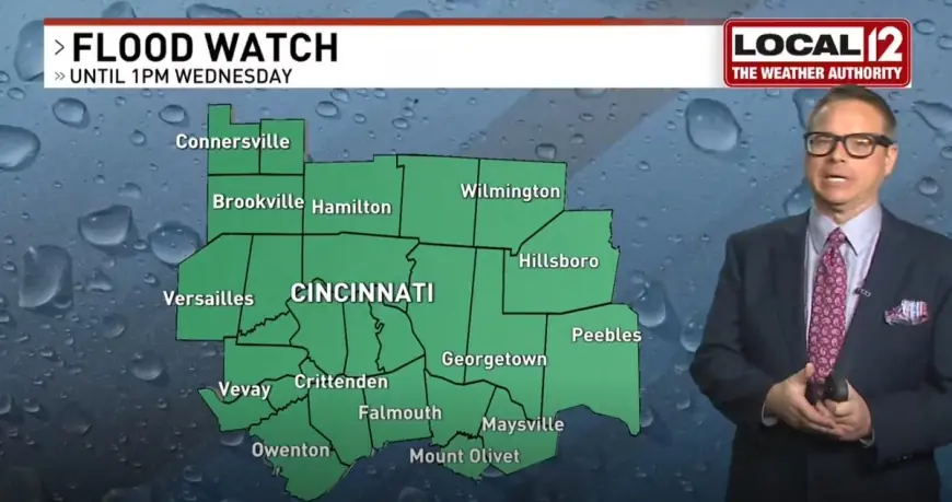
A Flood Warning has been issued for the Little Miami River near South Lebanon in Warren County, Ohio, running through 10:00 p.m. ET today. A Flood Watch remains in effect for Butler, Clinton, Greene, Montgomery, Preble, and Warren counties in Ohio, as well as Union and Wayne counties in Indiana, through 1:00 p.m. ET today.
Small streams are already rising and elevated levels are being recorded on both the Great Miami River and Little Miami River in the Tri-State area. Both rivers are under an active Flood Warning as water continues rising through the afternoon hours.
Rain activity is expected to break up and turn more isolated by midday, with a few drier hours possible between 11:00 a.m. and 4:00 p.m. ET. A new round of scattered showers and storms will develop between 5:00 p.m. and midnight, with the Storm Prediction Center placing the area in a marginal risk for severe storms capable of producing large hail.
Active Flood Alerts by State: Where to Watch Today
| State | Alert Type | Rivers/Counties Affected |
|---|---|---|
| Ohio | Flood Warning | Little Miami River, Warren County |
| Ohio | Flood Watch | Butler, Clinton, Greene, Montgomery, Preble, Warren |
| Indiana | Flood Watch | Union, Wayne counties |
| West Virginia | Flood Watch | Tri-state region, multiple counties |
| Ohio/Indiana/KY | Flood Advisory | Great Miami River watershed |
West Virginia: Multi-Day Flood Threat
Residents across much of the West Virginia tri-state region are being urged to stay alert this week as a flood watch was issued through Wednesday ahead of a multi-day stretch of rain that forecasters say could overwhelm local waterways and drainage systems. Up to 2 inches of rain accumulated quickly, with the ground unable to absorb it fast enough, leading to rapid runoff that pushed streams, creeks, and low-lying areas to their limits.
While the heaviest flooding concerns were concentrated on Tuesday and Wednesday, additional rounds of rain are forecast for the remainder of the week — lighter but still capable of adding up for areas that have already absorbed significant moisture throughout the week.
Ohio: Miami Valley Hit Hard
The flood watch in the Miami Valley covers areas along and south of Interstate 70. Two to three inches of rain fell across the region, with the heaviest band setting up south of Dayton and continuing through overnight hours. Dayton area meteorologists urged residents not to drive through flooded roads under any circumstances.
Spring Flood Outlook 2026: What Comes Next
The National Weather Service 2026 Spring Flood Outlook indicates overall flood risk this spring remains below average across most of the country, with one notable exception. Due to above-average snowpack in western Upper Michigan, the Menominee River system is expected to see an above-average risk of flooding relative to historical patterns.
Factors increasing spring flood risk nationally include above-normal frost depth, river ice in northern zones, and spring precipitation forecast to be above normal again this year. If heavier rain occurs alongside a more rapid snowmelt event, the overall flood risk across the Upper Midwest will increase significantly.
Flood Watch vs. Flood Warning: Know the Difference
A Flood Watch means the ingredients to create flood conditions are present and flooding is possible — you should be prepared. A Flood Warning means flood conditions are imminent or actively occurring — you should take action immediately, move to high ground, and never attempt to walk or drive through floodwaters. Remember the phrase: "Turn around, don't drown."
Sign up for Wireless Emergency Alerts on your phone, tune to local weather radio, or download your local NWS app to stay informed in real time as conditions change through the rest of this week.