


Cyclone Alert Issued as Heavy Rains Drench Queensland
Queensland is experiencing severe weather conditions as heavy rains continue to impact the region, particularly in the north. Over the past 24 hours, some areas recorded more than 200 millimeters of rain, prompting a cyclone alert and flood warnings across affected regions.
Cyclone Alert Issued: Heavy Rains Drench Queensland
The Bureau of Meteorology (BOM) reported that Abergowrie Bridge, situated north of Townsville, received 231 mm between 9 AM on Sunday and 6 AM on Monday. Other notable rainfall totals included:
- Poverty Hill: 107 mm
- Trebonne: 120 mm
- Cardwell Gap: 130 mm
- Gairloch: 136 mm
- Euramo (outside Tully): 195 mm
Forecasts predict that the coastline could see an additional 350 mm of rainfall before the weekend concludes. Innisfail is expected to receive up to 110 mm of rain on Monday, with high chances of 90 mm falling daily until Friday in worst-case scenarios.
Flood Risks and Warnings
In light of the significant rainfall, a flood warning has been issued for the Pioneer River catchment. This alert remains active as areas south of Mackay continue to experience extreme weather, with Eungella recording 133 mm. Several regions in Pioneer Valley reported over 100 mm of rain throughout Sunday into the early week.
Senior meteorologist Felim Hanniffy indicated a prolonged flooding condition might persist for several weeks in far-western Queensland. Rivers in the Georgina-Eyre Creek catchments are expected to rise, with ongoing flood watch advisories in effect.
“It’s difficult to predict peak flood levels,” Hanniffy stated. “Due to the vast area impacted, water takes time to move downstream.”
Response and Preparations
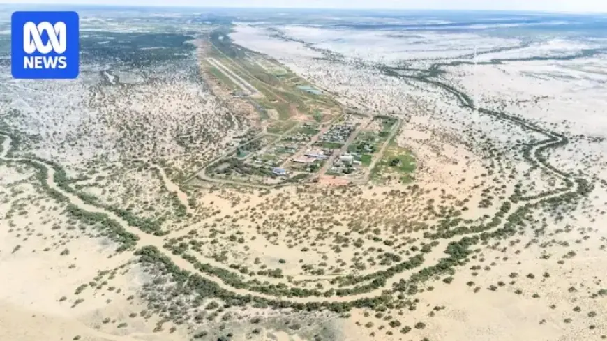
The Diamintina Shire is preparing for extended isolation, with all roads currently impassable due to floodwaters. The Shire Council is collaborating with the government and local suppliers to ensure essential supplies reach affected residents.
Queensland Premier David Crisafulli acknowledged the challenging times ahead, stressing the need for careful resupply of food and medical supplies to isolated areas.
Potential Cyclone in Northern Queensland
As the active monsoon trough strengthens, two tropical lows are poised to bring further heavy rainfall to the region. One low is located in the Gulf of Carpentaria and another in the Coral Sea. The BOM has indicated a 25 percent chance of one of these systems developing into a cyclone by Friday.
Regardless of the cyclone’s formation, the likelihood of heavy rainfall remains, increasing the risk of both riverine and flash flooding across already saturated areas.
Ongoing Flood Warnings
A major flood warning is in effect for the Herbert River, particularly affecting residents in Halifax, north-east of Ingham. Following a night of heavy rainfall, the river reached moderate flood levels, with forecasts indicating continued rises. The Halifax Washway is currently inaccessible, and the Anabranch Bridge may soon close.
Mayor Ramon Jayo reassured residents, stating they are familiar with flooding issues and likened monitoring river levels to a necessary precaution. Nearby highways have also experienced disruptions, with the Bruce Highway closing to one lane at the Seymour River bridge north of Ingham.
Residents are urged to remain cautious and prepared as Queensland braces for potentially historic weather conditions in the days ahead.