


Severe Flood Risk and Severe Storms Set to Ramp Up from Plains to Ohio Valley
An active storm pattern will bring multiple rounds of thunderstorms and a severe flood risk to the Plains through the Ohio Valley beginning Wednesday, creating a multiday weather threat that matters for travel, flood-prone communities and drought relief prospects. Forecasters point to a slow-moving upper-level low and a surge of Gulf moisture as the immediate drivers of heavy rain and severe thunderstorm potential over several days.
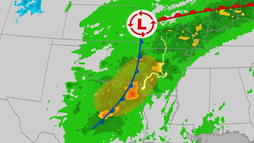
Severe Flood Risk: Areas at Risk
Thunderstorm activity is expected to affect a broad corridor from Texas into the Ohio Valley. Early rounds of storms will arrive Wednesday afternoon and evening, with additional rounds likely later in the week and into the weekend. The pattern creates a multiday risk of heavy rain and localized flooding from Texas northward through parts of the Plains and into the Mississippi and Ohio River valleys. Secondary rivers in some locations may see significant rises.
Timing and Storm Hazards
The week’s initial round is timed for Wednesday, with repeated storm chances on Thursday and Thursday night and again Friday into Saturday. Meteorological setup includes a slow-moving upper-level low approaching the Central Plains, breezy south winds transporting Gulf moisture northward, and a notable southward dip in the jet stream over the western U. S. paired with a northward bulge in the East. That combination is expected to maintain rounds of rain and thunderstorms over multiple days.
Any given thunderstorm in the corridor could produce large hail, strong gusty winds and isolated tornadoes. Forecast parameters noted for the period include damaging wind gusts up to about 70 mph, with a local extreme storm gust potential of near 80 mph in the most intense cells. Flooding is an increasing concern as rounds of heavy rain accumulate over short time spans.
Outlook and Preparedness
Storm chances and the severity of impacts will depend on the timing and strength of each system as it progresses. The initial rounds of rain are expected to provide some drought relief in affected areas, but persistent rounds through the week raise the odds of flooding as soils become saturated and waterways respond to repeated runoff. There is also a downstream risk that warmer conditions farther north, combined with rainfall, could elevate ice-jam and river-flood concerns in parts of the Midwest and Northeast.
Officials have issued first-alert-level weather days for key periods later in the week, signaling the need for heightened awareness. Residents in the projected corridor should prepare multiple ways to receive warnings and review local flood and severe-thunderstorm safety plans. Actions that reduce downstream impacts include avoiding driving through flooded roadways and maintaining situational awareness if located near smaller tributaries and secondary rivers prone to rapid rises.
Near-term Forecast Signals
Observable indicators pointing to elevated risk this week include the approaching upper-level low, the steady inflow of Gulf moisture, and repeated model support for a pattern of persistent rounds of precipitation. If rounds remain frequent and training occurs, localized flash flooding and rises on smaller rivers are the most likely outcomes. If individual storms lock onto a stronger instability axis, expect the usual severe hazards of large hail, damaging winds and isolated tornadoes.
Decision-makers and residents should watch updated forecasts as details refine closer to each round of storms. Uncertainties remain about the precise placement and intensity of severe cells on any given day; those specifics will influence which communities face the greatest flooding and wind threats.