


Tropical Cyclone Horacio Becomes First Category 5 Storm of 2026, Poised to Weaken over Open Indian Ocean
Tropical Cyclone Horacio reached Category 5 strength late in the Southern Hemisphere cyclone season and now shows signs of steady weakening as it moves south into cooler waters and higher wind shear. The escalation to very intense status produced extreme winds and high seas that prompted warnings for Rodrigues and precautionary advisories from regional meteorological agencies.
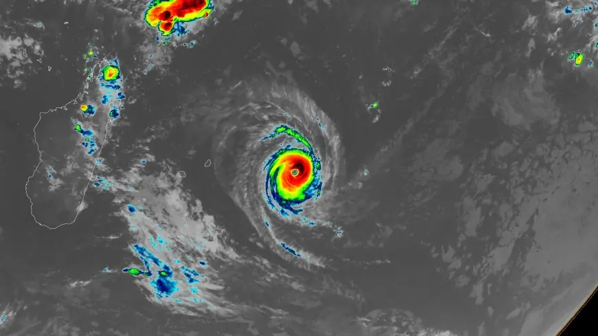
Tropical Cyclone Horacio: peak intensity and wind measurements
The system topped out with 1-minute sustained winds near 160 mph (260 km/h), a value used by the Joint Typhoon Warning Center (JTWC) to place Horacio at Category 5 on the Saffir–Simpson scale. Regional measurements differed slightly: RSMC La Réunion estimated 10-minute sustained winds around 230–240 km/h (140–150 mph), gusts near 280–300 km/h (175–185 mph) and a central pressure of approximately 910 hPa. Satellite imagery captured a symmetrical eye and robust convective bands at the storm’s height. Observers noted the storm reached its very intense status by February 22, and it was described as the world’s first Category 5 tropical cyclone of 2026 on February 23 by a climate analyst who published an assessment on February 23, 2026.
RSMC La Réunion classification and forecasted weakening
RSMC La Réunion classified the system as a "Very Intense Tropical Cyclone, " the basin’s highest rating and a designation that typically occurs only once or twice in a season. Meteorologists at RSMC La Réunion issued a forecast update at 07: 32 UTC on February 24 noting that environmental conditions were expected to deteriorate, with increasing vertical wind shear partially offset by strong upper-level divergence and an outflow channel to the southeast. Both RSMC and the JTWC predicted a southward track over cooler waters, with a steady weakening trend and an expected transition into a post-tropical system within roughly 48 hours of February 24.
Development timeline from Rodrigues disturbance to very intense cyclone
The system developed from a low-pressure disturbance east of Rodrigues Island on February 18 and received the name Horacio from RSMC La Réunion on February 19. Rapid intensification followed: within 48 hours the cyclone strengthened over warm sea-surface temperatures and favorable upper-level outflow, reaching very intense status by February 22 and peaking between February 22 and 23. Satellite imagery time-stamped 04: 00 UTC on February 24 documented the mature structure, and by 06: 00 UTC on February 24 the center lay about 315 km (196 miles) southeast of Rodrigues while the cyclone continued moving south and weakening.
Warnings, swell impacts and local observations for Rodrigues and Mauritius
Mauritius Meteorological Services (MMS) maintained a Class 1 Cyclone Warning until February 23 and lifted it as the system moved away. Outer rainbands delivered periods of rain and strong gusts to Rodrigues, where winds reached about 100 km/h (60 mph) and seas rose above 6–8 m (20–26 feet). MMS issued a Heavy Swell Warning for Rodrigues at 04: 30 LT (00: 30 UTC) on February 24, valid until 04: 00 LT (00: 00 UTC) on February 25, cautioning that high-energy swells generated by the cyclone would produce swells of 7 m (23 feet) beyond the reefs and could cause waves to influence lagoons and break along low-lying coastal areas, especially at high tide. Fishermen, pleasure-craft operators and the public were strongly advised not to venture to sea or along beaches while the warning remained in effect. No major damage or casualties were reported in the warnings and advisories released by regional agencies.
Regional tracking, wider context and climatic note
The cyclone tracked south-southwestward east of Mauritius before turning south across open waters. It is far from any land areas and presented its primary hazard to marine interests. What makes this notable is that Horacio is the first Category 5 in the Southern Hemisphere since Cyclone Errol reached that status off northwestern Australia on April 16, 2025. Long-term climatology shows an average of 5. 3 Category 5 storms globally per year for 1990–2025, and there were five Category 5 systems in 2025: Hurricanes Melissa, Erin and Humberto in the Atlantic; Typhoon Ragasa in the Northwest Pacific; and Cyclone Errol in the South Indian Ocean. Climate researchers note the expectation that the proportion of tropical cyclones reaching Category 4 and 5 strength will increase, a factor relevant to understanding trends in extreme cyclone intensity.
The combined assessments from JTWC, RSMC La Réunion and regional agencies paint a coherent short-term outlook: the intensity peak has passed and Tropical Cyclone Horacio will continue to weaken as it moves into less supportive oceanic and atmospheric conditions, though the system will continue to influence seas and coasts until it fully transitions to a post-tropical state.