


Weather: Blizzard Warnings Expanded, Flights Canceled as Northeast Braces
The weather outlook calls for a dangerous and potentially historic winter storm set to slam the Tri-State area later today, bringing blizzard conditions, heavy snow, damaging winds and coastal flooding. Thousands of U. S. flights have been canceled and officials have expanded warnings as communities prepare for whiteout conditions.
Storm timeline and expected intensity
The system will begin this morning with scattered light snow and rain, then rapidly intensify through the afternoon and peak overnight. The strengthening coastal storm will pull up the East Coast and tap into just enough cold air to flip rain to snow across New York City and New Jersey by midday; after lunchtime, snow becomes more widespread and significantly more intense.
By evening, heavier bands are expected to develop with snowfall rates of 1 to 2 inches per hour. Tonight is described as the worst period, with widespread heavy snow and near-zero visibility. Monday morning will see heavy snow continue through the early morning, improving by mid-morning, with snow tapering in the second half of the day while winds remain strong and travel continues to be impacted.
Weather: Snowfall, winds and flooding
Forecasters say the storm is poised to be the biggest snow-maker to slam the Tri-State area since the storm of January 2016, which was the biggest snowstorm to ever hit New York City on record. The last blizzard warning in the region was in March 2017, making this a rare event. The system involves the convergence of energy from the Ohio Valley colliding with Gulf and ocean moisture, producing a storm that almost resembles a winter hurricane.
Expected wind gusts vary by source and timing: gusts of 50 to 60 mph are possible near the coast, while the National Weather Service warned gusts could reach up to 55 mph, creating whiteout conditions that "will make travel treacherous and potentially life-threatening. " Forecasters added that the "strong winds, combined with the weight of heavy, wet snow, will likely result in scattered to numerous power outages. "
Coastal flooding is also a major threat, with winds pushing water inland and up to 3 feet of coastal inundation possible around high-tide cycles tonight into Monday morning, especially along Long Island and the Jersey Shore.
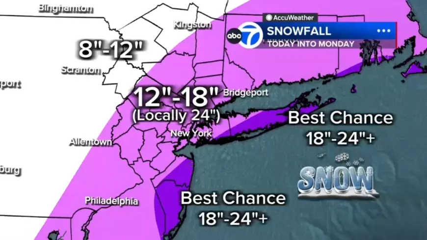
Snow totals and local variations
Every county in the region is under a Blizzard Warning. Forecast totals include 12 to 18 inches across most of the region, with localized 18 to 24 inches in a central corridor from the Jersey Shore to Long Island. The best chance for 24-plus inches is on the East End of Long Island and parts of the Jersey Shore. Up to 12 inches are expected north and west in Pike, Sullivan and Ulster counties.
Separate forecasts note the heaviest snow will begin Sunday night, with potential totals Sunday night into Monday topping 18 to 24 inches in New York City, Philadelphia and Boston.
Air travel disruptions and cancellations
Thousands of flights have been canceled across the U. S. as the Northeast rushes to prepare. The total number of disrupted flights reached more than 7, 000 as of 6 a. m., with 6, 456 U. S. flights canceled and an additional 547 U. S. flights delayed so far through Tuesday. Major carriers announced they will waive change and cancellation fees ahead of the storm to help travelers adjust plans at busy Northeast hubs.
Images from the region show maintenance crews clearing snow from the taxiway at LaGuardia Airport as a major winter storm spreads, dated Jan. 26, 2026, and travelers waiting for flights at John F. Kennedy International Airport on Nov. 18, 2025.
Local impacts, roads and visibility
Light snow is already falling across Sullivan, Ulster, Dutchess and Orange counties and parts of northwest New Jersey, while most of New Jersey is seeing rain early. Some sleet mixed in around Ocean County before transitioning to rain. Roads begin the day wet, which may delay initial snow accumulation, but that won't last long. Visibility is already reduced in spots, with White Plains down to 0. 2 miles, and travel is expected to grow increasingly difficult as heavier snow organizes later today.
Tonight's conditions include whiteout visibility and a widespread power outage potential due to downed trees and lines. Officials list risks of near-zero visibility and heavy, wet snow that heightens outage risk.
Transit suspension and official action
New Jersey Governor Sherrill announced that NJ Transit buses will be suspended at 6: 00 p. m. today, and that trains are likely to follow later. Communities across the region are under warnings or watches: blizzard warnings are in place for New York City and the New Jersey coastline, while winter storm watches and warnings are in effect for Boston, Philadelphia, Washington, D. C., and Baltimore.
Separately, coverage of the unfolding storm notes human impacts: a Tennessee man died after suffering a heart attack while shoveling snow, a fatality that adds to the storm toll. Broad cautions about travel, power outages and health risks accompany the emergency messaging.
Stay tuned for frequent live updates as the storm arrives and conditions evolve.