


Blizzard Warnings Expand as Gov. Sherrill Declares State of Emergency in New Jersey
Blizzard conditions are expected to develop across the Tri-State area and parts of the Mid-Atlantic as a strengthening coastal storm moves up the East Coast. The threat matters now because the storm is forecast to intensify through the afternoon and peak overnight, bringing heavy snow, damaging winds and coastal flooding precisely during high-tide cycles.
Gov. Sherrill Declares State of Emergency in New Jersey
New Jersey’s governor, Sherrill, has declared a state of emergency ahead of the winter storm as every county in the region has been placed under a Blizzard Warning. The declaration follows forecasts of widespread heavy snow, gusty winds and a coastal inundation threat that could reach up to 3 feet around high-tide cycles tonight into Monday morning, especially along Long Island and the Jersey Shore.
Blizzard Warnings Cover Philadelphia, New Jersey and Delaware
A Blizzard Warning will go into effect Sunday for most of the viewing area referenced and now includes Philadelphia, several suburban Pennsylvania counties, the entirety of New Jersey and Delaware. The designation means three or more hours of winds gusting to 35 miles per hour or greater, falling or blowing snow, and visibility less than a 1/4 of a mile; there is no requirement for a specific amount of snow to meet the blizzard definition.
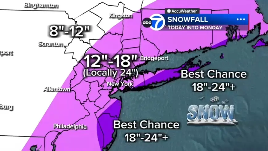
Snow Totals and Wind: 12–18 Inches with Localized Higher Amounts
Forecast totals call for 12 to 18 inches across most of the region, with a central corridor from the Jersey Shore to Long Island picking up localized 18 to 24 inches. The best chance for 24-plus inches is on the East End of Long Island and parts of the Jersey Shore. Up to 12 inches are expected north and west in counties such as Pike, Sullivan and Ulster. Snowfall rates of 1 to 2 inches per hour are expected once heavier bands organize, and wind gusts could reach 50 to 60 mph near the coast.
New York City, Tri-State Progression and Local Conditions
The storm will begin the day with a light mix of snow and rain across parts of the Tri-State area, with light snow reported in Sullivan, Ulster, Dutchess and Orange counties and in parts of northwest New Jersey. Most of New Jersey was seeing rain early, and some sleet mixed in around Ocean County before changing to rain. Roads are wet this morning, which may delay initial snow accumulation, while visibility has already fallen in spots—White Plains was down to 0. 2 miles.
The strengthening coastal storm is expected to tap into enough cold air to flip rain to snow across New York City and New Jersey by midday, with snow becoming more widespread and intense after lunchtime. By evening, heavier bands will push through and conditions will deteriorate rapidly into widespread heavy snow and near-zero visibility.
Philadelphia Temperatures, Timing and Travel Advice
Sunday is forecast to be cloudy and cooler, with rain and snow showers developing and a high near 39 degrees. Ground temperatures above freezing and air temperatures in the mid 30s mean areas northwest of Philadelphia will likely begin with light snow showers that may melt on contact at first; a mix of rain and snow is expected around the city with rain showers for south and east sections. As temperatures fall later in the evening, precipitation will change over to snow for all areas, and the timing of the heaviest snow overnight creates ideal conditions for accumulation.
Drivers are urged to use caution and consider staying off the roads from Sunday evening through Monday morning as snowfall rates pick up and blowing snow reduces visibility. Travel could be very difficult to impossible when blizzard conditions develop, and gusty winds could bring down tree branches and produce isolated power outages.
Coastal Flooding Threat for Long Island and Jersey Shore
Winds whipping off the ocean will push water inland, creating the potential for up to 3 feet of coastal inundation around high-tide cycles tonight into Monday morning, with beach erosion also noted in alert postings. Officials have highlighted the dual threat of heavy snow and coastal flooding as the coastal storm strengthens and moves away, with snow beginning to taper off from west to east by Monday morning.
Historic Context and Local Impacts, Including Broadway
Forecasters say the system could be the biggest snow-maker to strike the Tri-State area since the January 2016 storm, which stands as the largest snowstorm on record for New York City, and noted that the last blizzard warning was issued in March 2017. The forecast includes a significant power outage risk from downed trees and lines. Despite the expected deterioration, Broadway matinee performances with curtain times at 3 pm or earlier will proceed as planned.
What makes this notable is the convergence of energy from the Ohio Valley colliding with Gulf and ocean moisture, producing a coastal storm that meteorologists say almost resembles a winter hurricane; that mechanism is driving the rapid intensification and the combination of heavy snow, high winds and coastal flooding.