


Blizzard threat widens across Tri-State as New Jersey declares state of emergency
A powerful winter storm is set to slam the Tri-State area Sunday night into Monday, bringing blizzard conditions that could make travel impossible and produce widespread outages. Meteorologist Jeff Smith warns this could be one of the most significant snowstorms the region has seen in years and the state of emergency declared in New Jersey underscores the immediate risk.
Blizzard warning area and timing
A blizzard warning covers most of the Tri-State area and will go into effect on Sunday for Philadelphia and much of the surrounding viewing area. The heaviest snow is expected Sunday night and will continue into Monday, with true blizzard conditions possible Sunday night into Monday for 10 to 12 hours.
How the storm is forming and why it is so intense
The storm results from energy from the Ohio Valley colliding with Gulf and ocean moisture, producing a system that almost resembles a winter hurricane, meteorologists say. Forecasters note the setup could produce the region's most significant snowmaker since the January 2016 storm, which was the largest on record for New York City, and that the last blizzard warning before this was issued in March 2017.
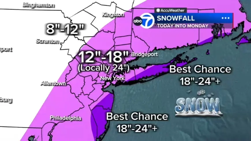
Projected snowfall totals and where the worst will be
Most of the region is projected to receive 12 to 18 inches of snow, with localized totals up to 24 inches or more where the heaviest bands stall. Long Island and parts of the Jersey Shore have the highest likelihood of hitting those extreme amounts. Farther north and west, including the Poconos and Catskills, amounts are expected to be lower—roughly 8 to 12 inches—because those areas have less access to the storm's core moisture.
Winds, blizzard criteria and coastal threats
This storm meets the criteria for a full-blown blizzard: winds gusting 35 mph or higher, heavy snow, and visibility under a quarter mile for at least three consecutive hours. Winds will increase through Sunday and peak overnight, with gusts over 40 mph across the region, potentially up to 60 mph on Long Island and gusts along the coast likely reaching 50 mph. Coastal flooding and beach erosion are likely, and thundersnow is possible in southeastern New Jersey and southern Delaware where very strong lift develops.
Timing, temperatures and travel measures
Conditions stay quiet Saturday evening before clouds thicken overnight. Light precipitation should begin Sunday morning, with a few rain or snow showers possible early in the day while temperatures remain above freezing. The high on Sunday is forecast near 39, with ground temperatures above freezing and air temperatures in the mid 30s leading to initial melting where snow first falls. By midday Sunday visibility will begin dropping as steadier snow develops—especially from New York City south and west—and after sunset temperatures will fall as the storm intensifies offshore and pulls heavy snow bands into the region.
Bands of snow could drop 2 to 3 inches per hour and may sit overhead for hours. Drivers are urged to exercise caution and consider staying off roads from Sunday evening through Monday morning; New Jersey has issued a commercial vehicle travel restriction on multiple Interstate highways starting at 3 p. m. Sunday, and Gov. Mikie Sherrill has declared a State of Emergency for New Jersey as winter weather is expected to begin Sunday and continue into Monday, creating treacherous driving conditions. Road conditions are expected to deteriorate rapidly Sunday evening and the Monday morning commute may be impossible in some areas.
Aftermath and short-term outlook
Snow will gradually taper Monday afternoon, though gusty winds and scattered blowing snow will continue, with lingering morning snow showers and a high near 38 on Monday. Tuesday will turn colder and breezy with cleanup underway, and another system is possible Wednesday though early indications suggest it will be significantly weaker.