


Blizzard Warning: Major East Coast Storm Could Be Biggest Since 2016
A blizzard warning is in effect across most of the Tri-State area as a powerful winter storm is set to slam New York City Sunday night into Monday, bringing blizzard conditions, dangerous travel and the potential for widespread power outages. Meteorologist Jeff Smith says this could be one of the most significant snowstorms the region has seen in years.
Blizzard Warning in effect across most of the Tri-State area
A blizzard warning covers most of the Tri-State as the storm is poised to be the biggest snow-maker to slam the region since the storm of January 2016, which was the biggest snowstorm to ever hit New York City on record. The last time the area faced a blizzard warning was in March 2017, making this a rare event.
How the storm will unfold and where the heaviest snow will fall
Forecasters say the storm forms when energy from the Ohio Valley collides with Gulf and ocean moisture, producing a system that almost resembles a winter hurricane. Conditions are expected to be quiet Saturday evening, with clouds thickening overnight. A few rain or snow showers may appear early Sunday while temperatures remain above freezing to start the day; by midday Sunday visibility will begin dropping as steadier snow develops, especially from New York City south and west. After sunset temperatures fall and the storm rapidly intensifies offshore, pulling heavy snow bands directly into the region.
Rapid accumulation, coastal extremes and inland differences
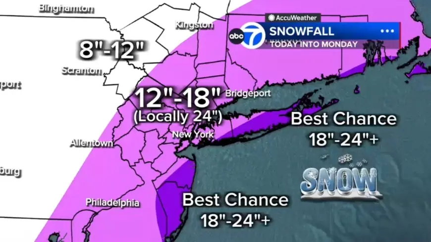
Bands of snow could drop 2 to 3 inches per hour, and in some places those bands may sit overhead for hours. Most of the region is projected to see 12 to 18 inches, with localized totals up to 24 inches or more where the heaviest bands stall; Long Island and parts of the Jersey Shore currently have the highest likelihood of hitting those extreme amounts. Farther north and west, including the Poconos and the Catskills, amounts are expected to be lower, roughly 8 to 12 inches, because those locations have less access to the storm's core moisture.
Winds, outages and travel impacts
This blizzard warning meets the criteria for a full-blown blizzard: winds gusting 35 mph or higher, heavy snow and visibility under a quarter mile for at least three consecutive hours. The area may see 10 to 12 hours of true blizzard conditions Sunday night into Monday. Winds will increase throughout Sunday, peaking overnight with gusts over 40 mph across the region and potentially up to 60 mph on Long Island. Combined with wet, heavy snow, the storm poses a significant risk for downed trees and power outages.
Roads, flights and the short-term timeline
Road conditions are expected to deteriorate rapidly Sunday evening, and the Monday morning commute may be impossible in some areas. More than 6, 400 flights have been canceled ahead of the blizzard, and over half of all flights at JFK and LaGuardia have already been canceled. Snow will gradually taper Monday afternoon, though gusty winds and scattered blowing snow will continue.
What comes next
Tuesday will turn colder and breezy with leftover cleanup underway. Another system is possible Wednesday, but early indications suggest it will be significantly weaker. Live updates will be posted frequently as conditions change and recovery and flight operations are adjusted; the next confirmed change in conditions is the expected gradual taper of snow Monday afternoon followed by colder, breezy conditions on Tuesday.