


Blizzard warning expands as nor'easter threatens Tri-State with historic snowfall
A powerful blizzard is expected to slam New York City and the Tri-State area Sunday night into Monday, bringing dangerous travel, the risk of widespread power outages and major disruptions to transportation and local services. Officials and forecasters warn the storm could be the region's most significant snowmaker since 2016.
Meteorologist Jeff Smith outlines storm structure and timing
Meteorologist Jeff Smith says the system involves the convergence of energy from the Ohio Valley colliding with Gulf and ocean moisture, producing a storm that almost resembles a winter hurricane. Conditions are expected to stay quiet Saturday evening while clouds thicken overnight; a few rain or snow showers may appear early Sunday with temperatures above freezing to start the day.
By midday Sunday visibility will begin dropping as steadier snow develops, especially from New York City south and west. After sunset, temperatures fall and the storm rapidly intensifies offshore, pulling heavy snow bands directly into the region. Those bands could drop at 2 to 3 inches per hour, and in some areas they may sit overhead for hours.
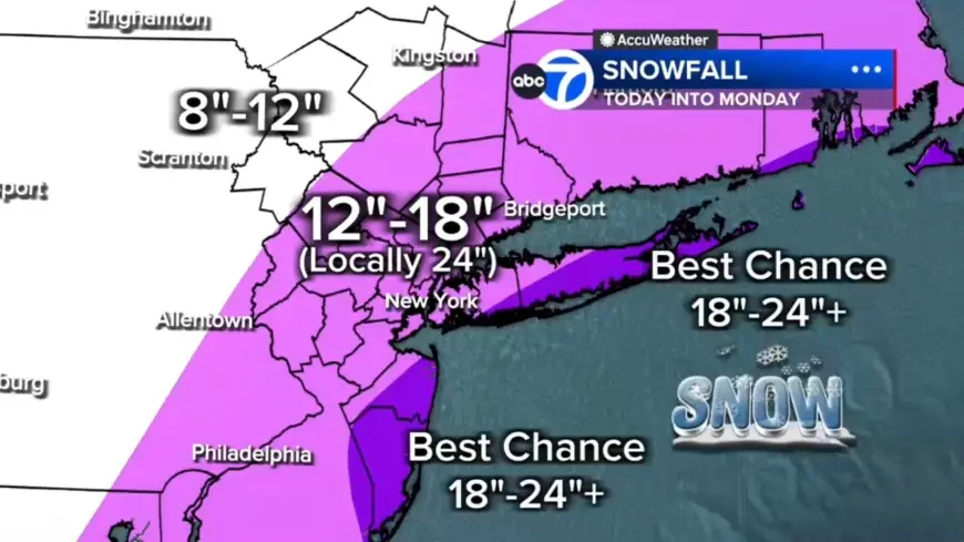
Forecast totals show heavy snow for Long Island and Jersey Shore
Most of the region is projected to see 12 to 18 inches of snow, with localized totals up to 24 inches or more where the heaviest bands stall. Long Island and parts of the Jersey Shore currently have the highest likelihood of hitting those extreme amounts. Farther north and west, including the Poconos and Catskills, amounts are expected to be lower—roughly 8 to 12 inches—because those areas will have less access to the storm's core moisture.
Blizzard warnings, coastal flood watches and broad alerts in place
A blizzard warning is in effect across most of the Tri-State area. The National Weather Service has upgraded southern Delaware, the Jersey Shore, all of New York City, Long Island and coastal Connecticut to a blizzard warning for increased confidence in snowfall of more than one foot and gusty winds that will likely cause blizzard conditions.
Coastal flood watches are up from coastal Delaware to the Jersey Shore and Long Island to the coast of southern New England for minor to moderate coastal flooding during high tide. As of Saturday morning, more than 40 million Americans are on alert for winter storm conditions beginning on Sunday and continuing into Monday.
State actions: New Jersey emergency declaration and local snow emergencies
Governor Mikie Sherrill declared a state of emergency for all 21 counties in New Jersey starting at 12 p. m. Sunday ET. Residents were asked to seek official state preparedness information for updates. "Beginning tomorrow and continuing into Monday, we expect to see a winter storm bring severe blizzard conditions across our state, " Governor Sherrill said. "We are urging all New Jerseyans to use caution, stay off the roads, and follow all safety protocols during the storm. "
Snow emergencies have been declared in communities across suburban Pennsylvania in anticipation of the major winter storm set to hit Sunday into Monday; local municipalities are issuing timing and restriction updates and lists of towns under snow emergency will be updated as new notifications are received.
Transportation disruptions, wind threats and the outlook through midweek
Winds will increase throughout Sunday, peaking overnight with gusts over 40 mph across the region and potentially up to 60 mph on Long Island. This, combined with wet, heavy snow, poses a significant risk for downed trees and power outages. The storm meets full-blown blizzard criteria: winds gusting 35 mph or higher, heavy snow and visibility under a quarter mile for at least three consecutive hours; the area may see 10 to 12 hours of true blizzard conditions Sunday night into Monday.
Road conditions will deteriorate rapidly Sunday evening and the Monday morning commute may be impossible in some areas. American Airlines said it will suspend operations at LaGuardia, JFK and Philadelphia beginning Sunday afternoon through the day Monday due to the blizzard. "Teams across the airline are working around the clock and will be ready to resume operations at the affected airports Tuesday, Feb. 24 as soon as the conditions allow airlines to safely do so, " the statement said.
Snow is expected to gradually taper Monday afternoon, though gusty winds and scattered blowing snow will continue. Tuesday turns colder and breezy with cleanup underway. Another system is possible Wednesday, but early indications suggest it will be significantly weaker. Forecasts also show the coastal storm starting to take shape over the coastal Carolinas on Sunday, bringing rain to the Mid-Atlantic and scattered light to moderate snow from Northern Virginia into Pennsylvania and parts of New Jersey and New York by Sunday morning into the afternoon, before quickly intensifying off the coast of North Carolina and Virginia late Sunday afternoon as it tracks to the Northeast and parallels the East Coast, with heavy snow, strong gusts and coastal flooding anticipated by early Monday morning across much of the coastal Northeast.