


Blizzard Warning: blizzard warning hits NYC area as projected snow totals rise again; LI may see worse
NEW YORK — A blizzard warning is in effect as a powerful winter storm is set to slam New York City and the Tri-State area Sunday night into Monday, bringing blizzard conditions, dangerous travel and the potential for widespread power outages. Meteorologist Jeff Smith says this could be one of the most significant snowstorms the region has seen in years.
Blizzard Warning areas and timing
Blizzard Warnings are in effect for Long Island, all five boroughs, Westchester and Rockland counties, coastal Connecticut and much of New Jersey. The area may see 10 to 12 hours of true blizzard conditions Sunday night into Monday, with visibility under a quarter mile for at least three consecutive hours.
Storm development and timeline
Conditions stay quiet Saturday evening, with clouds thickening overnight. A few rain or snow showers may pop up early Sunday while temperatures remain above freezing to start the day. By midday Sunday, visibility will begin dropping as steadier snow develops, especially from New York City south and west. After sunset, temperatures fall and the storm rapidly intensifies offshore, pulling heavy snow bands directly into the region.
Snow totals and rates
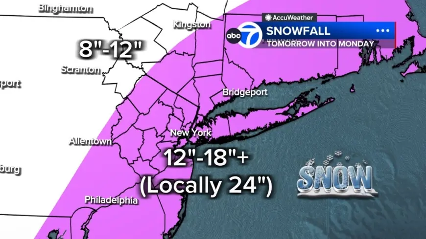
Bands of snow could dump at 2 to 3 inches per hour, and in some areas those bands may sit overhead for hours. Most of the region is projected to see 12 to 18 inches, with localized totals up to 24 inches or more where the heaviest bands stall. Long Island and parts of the Jersey Shore currently have the highest likelihood of hitting those extreme amounts. Farther north and west, including the Poconos and Catskills, amounts are expected to be lower, roughly 8 to 12 inches, because of reduced access to the storm's core moisture.
Wind, visibility and blizzard criteria
This storm meets the criteria for a full-blown blizzard: winds gusting 35 mph or higher, heavy snow, and visibility under a quarter mile for at least three consecutive hours. Winds will increase throughout Sunday, peaking overnight with gusts over 40 mph across the region and potentially up to 60 mph on Long Island. Combined with wet, heavy snow, the storm poses a significant risk for downed trees and power outages.
Historic scope and warnings noted
Jeff Smith says this could be the biggest snow-maker to slam the Tri-State area since the storm of January 2016, which was the biggest snowstorm to ever hit New York City on record. The last time the region faced a blizzard warning was in March 2017, making this a rare event. Nationally, reporter Bryan Llenas notes the storm is expected to be historic in scope, with more than 29 million Americans under warning across the Northeast.
Impacts on travel, schools and cleanup
Road conditions will deteriorate rapidly Sunday evening, and the Monday morning commute may be impossible in some areas. Snow will gradually taper Monday afternoon, though gusty winds and scattered blowing snow will continue. Tuesday turns colder and breezy with leftover cleanup underway. Another system is possible Wednesday, but early indications suggest it will be significantly weaker. Due to the forecasted winter storm, Paterson Public Schools will be closed on Monday, February 23, 2026; all after-school programs are cancelled, and recreation programs will remain closed until further notice.
Forecast notes describe the storm as the convergence of energy from the Ohio Valley colliding with Gulf and ocean moisture, producing a system that almost resembles a winter hurricane. Stay with live updates and check back here for frequent updates as the situation evolves.