


Michigan Faces Mild Start, Braces for Significant Winter Storm
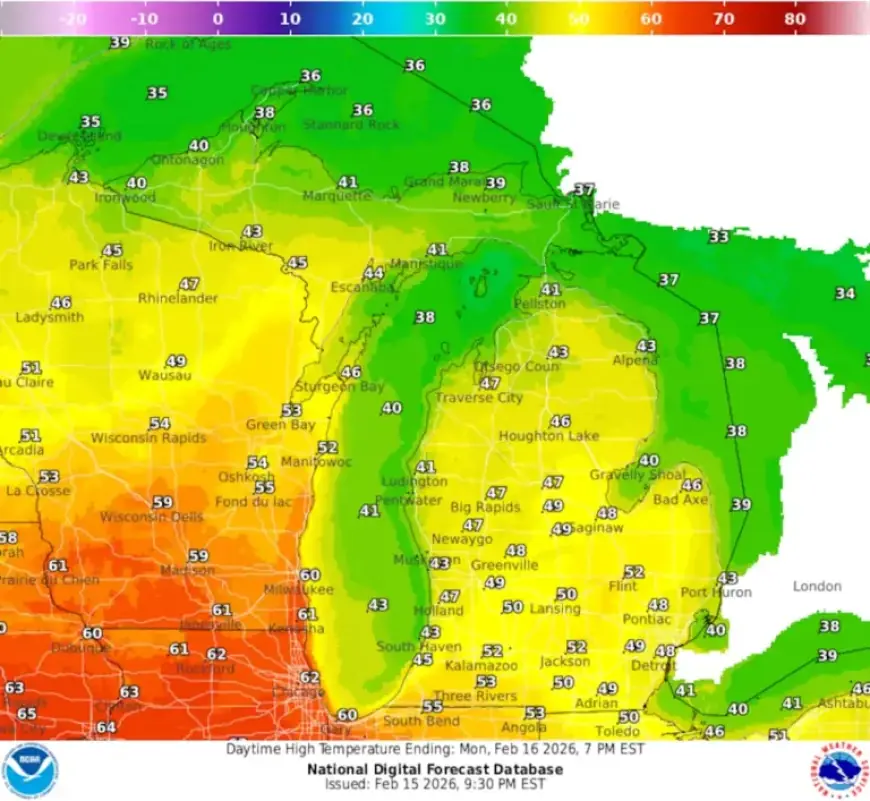
This week, Michigan is set to transition from a mild start reminiscent of spring to a significant winter storm. Temperatures are predicted to reach the 50s in southern regions, while Northern Michigan and the Upper Peninsula enjoy above-normal temperatures.
Michigan’s Upcoming Winter Storm
The National Weather Service warns residents of a major winter weather event from Tuesday night through Wednesday. The forecast indicates heavy snowfall, mixed precipitation, and strong winds affecting much of the state.
Forecast Highlights
- Gale Watches issued for portions of Lake Superior starting Tuesday afternoon.
- Heavy snow and freezing rain expected in Northern Michigan.
- Travel disruptions likely due to hazardous conditions.
Timing and Expected Conditions
The storm is forecast to hit late Tuesday and continue at least until Wednesday. The Upper Peninsula is poised to receive the heaviest snowfall, potentially exceeding six inches in some areas. In Northern Lower Michigan, varying precipitation types are anticipated.
Locations in the northern part might experience a mix of snow, sleet, and freezing rain. Meanwhile, southern Michigan is more likely to see rain, although freezing rain is still a possibility. Meteorologists caution that east-northeast winds could prevent warming, leading to ice accumulation.
Winds will strengthen, with gusts reaching 35 knots on northern Lake Huron from Wednesday morning through early afternoon. This combination of heavy precipitation and gusty winds raises concerns for power outages and treacherous travel conditions.
Near-Term Conditions
Before the storm hits, Michigan will enjoy mild temperatures. Monday’s highs could reach the 40s in the northern Lower Peninsula and low 50s near Saginaw Bay. However, patchy fog may reduce visibility to a quarter-mile in some areas.
- Light snow showers may occur late Monday in the eastern Upper Peninsula.
- Freezing rain is also a slight possibility.
- No significant impacts are expected from these conditions.
Extended Outlook
The weather pattern is likely to remain active beyond this week’s storm. A second low-pressure system may bring more precipitation from Thursday evening into Friday. Current models suggest less precipitation than the midweek system.
As temperatures normalize towards seasonal averages, additional chances for snow exist over the weekend. Recent mild weather combined with rain and potential snowmelt could lead to rises in local rivers, but flooding is not anticipated at this time.
Key Takeaways
- Michigan faces a significant winter storm from Tuesday night to Wednesday.
- The Upper Peninsula likely to see the most snowfall.
- Residents should prepare for potential travel disruptions and hazardous conditions.
Stay tuned to local forecasts for updates as the winter weather approaches. Visit Filmogaz.com for the latest news and updates on the weather across Michigan.