


Queensland Prepares for Severe 400mm Rainfall and Flash Flooding
Queensland is bracing for severe rainfall and flash flooding, with forecasts predicting up to 400mm over the next three days. The heaviest rain is anticipated on Friday, with isolated totals potentially reaching 150mm within just six hours.
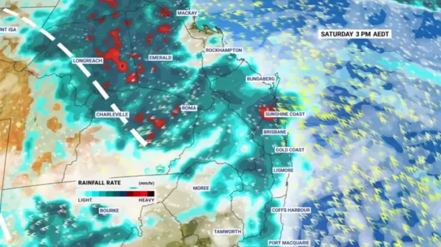
Rainfall Forecast and Expected Impact
According to Sky News reporter Kaiser Shields, significant rainfall in a short timeframe poses serious risks. Authorities have prepared accordingly, making about 140,000 sandbags available at five Brisbane City Council stations. Additional sandbagging sites are open in Moreton Bay, Redland, and Ipswich council areas.
Flooding Warning
The Bureau of Meteorology has issued warnings of potential minor to moderate flooding, particularly in smaller catchment areas. Isolated instances of major flooding are also possible. Meteorologist Tamsin Green emphasizes that severe thunderstorms could accompany high rainfall totals.
- Possible rainfall: Up to 400mm
- Heavy downpours: Expected on Friday
- Sandbags available: 140,000 at various locations
Weather Conditions Leading to Storms
The impending rain has been intensified by lingering tropical moisture from ex-Tropical Cyclone Mitchell, which recently drifted across Western Australia. This scenario is resulting in significant storm potential, as deep tropical moisture collides with cooler air moving into the region.
Uncertainties and Risks
While the exact locations of the heaviest rainfall remain uncertain, areas including the Sunshine Coast, Brisbane, and the Gold Coast are of particular concern. Green warns that the hit-or-miss nature of showers and thunderstorms complicates predictions.
- Uncertain areas for heavy rainfall: Sunshine Coast, Brisbane, Gold Coast, parts of New South Wales
- Potential for damaging winds: Possible, but heavy rain is the primary concern
Storms are expected to persist into the weekend, easing by early next week. Rainfall totals could spike significantly over these days, with as much as 300mm in the heaviest-hit spots.
Flash Flooding Risks
Forecasts indicate that flash flooding may pose the greatest threat if large rainfall amounts fall within short periods. There’s an increased risk that some of Friday’s totals could occur within a six-to-twelve-hour timeframe, which raises alarm for flash flooding incidents.