


Storms Sweep Nation, Cyclone Threat Looms
Australians nationwide are on alert as storms approach, accompanied by a potential cyclone. The Bureau of Meteorology warns of heavy rainfall and significant weather changes this weekend.
Storms Sweep Nation: Cyclone Threat Looms
As a developing tropical cyclone nears, states from Central to Southeast Australia brace for widespread thunderstorms and rainfall. Meteorologist Jonathon How highlighted the end of a prolonged dry spell, stating that much of Australia is finally set to receive much-needed rain.
End of a Dry Spell
This year has witnessed minimal rainfall across vast areas of Australia. Many regions, particularly in southern Northern Territory, western New South Wales, and inland South Australia, have recorded less than 10mm of rain. Some of these areas have seen totals drop below 2mm.
- Western Victoria and eastern South Australia reported no rainfall at all.
- The forecast predicts significant changes as multiple weather systems converge, including a tropical low developing near the Pilbara coast.
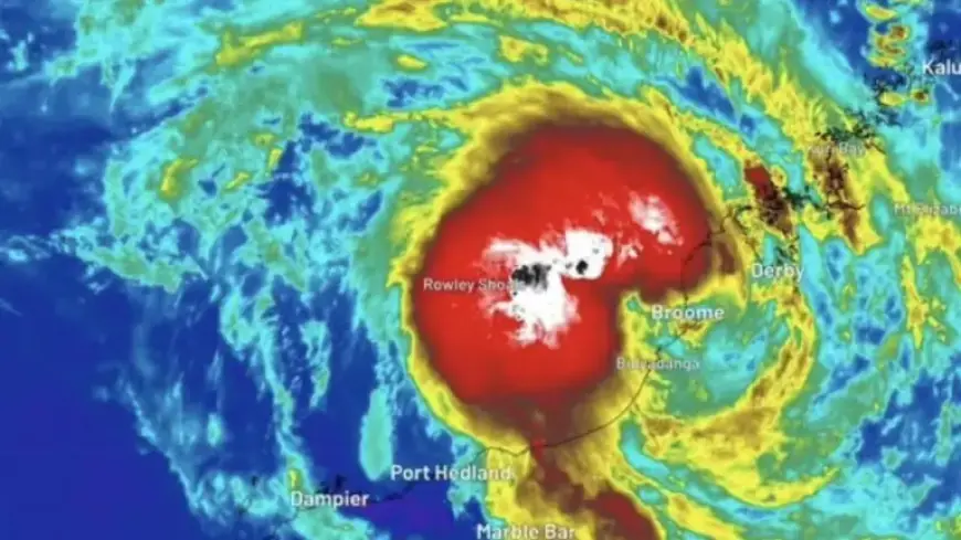
Cyclone Mitchell Expected to Form
The system is projected to develop into Tropical Cyclone Mitchell by late Saturday, intensifying into Sunday as it tracks southwest along the Pilbara coastline. As of 2 a.m. AWST on Friday, this low was situated 50 kilometers northeast of Broome and has already brought heavy rain to parts of the Kimberley.
- Curtin recorded 115mm of rain in 18 hours.
- Broome received over 50mm during the same time frame.
Once the tropical low moves offshore, it is expected to gain strength from warm waters, thus increasing the risk of heavy rain and damaging winds in coastal regions. Gusts could reach up to 120km/h, with flooding potential extending from the Kimberley throughout the weekend.
Severe Weather Warnings Issued
Communities in northern South Australia and western New South Wales are preparing for heavy rainfall as tropical moisture infiltrates the area. A severe weather warning has been issued, predicting 20 to 50mm of rain in just six hours on Saturday.
Localized thunderstorms could result in even higher totals, leading to the possibility of flash flooding. Estimates forecast 50 to 150mm of rainfall across southern Northern Territory and inland South Australia.
Thunderstorms Across the Country
Thunderstorms are set to extend from the Kimberley region through Central Australia and into New South Wales starting Friday. Severe weather may emerge around the Blue Mountains and Hunter Region, with heavy rainfall, strong winds, and large hail expected.
- Saturday’s storms are predicted to spread into South Australia, northern Victoria, and eastern New South Wales.
- On Sunday, major cities, including Melbourne, Hobart, Canberra, and Sydney, may experience severe thunderstorm impacts.
Emergency services have urged residents, especially those in northern Western Australia from the western Kimberley to northern Gascoyne, to stay vigilant. Preparing for possible flooding, power outages, and hazardous conditions is essential.