


Bomb Cyclone to Slam Southeast with Snow; Coastal New England at Risk
A significant coastal storm is developing this weekend, bringing the risk of a bomb cyclone to the Southeast. This storm is expected to deliver heavy snowfall, powerful winds, and coastal flooding, especially in New England. The unfolding conditions involve dangerously cold temperatures that pose serious risks to residents.
Storm Formation and Its Path
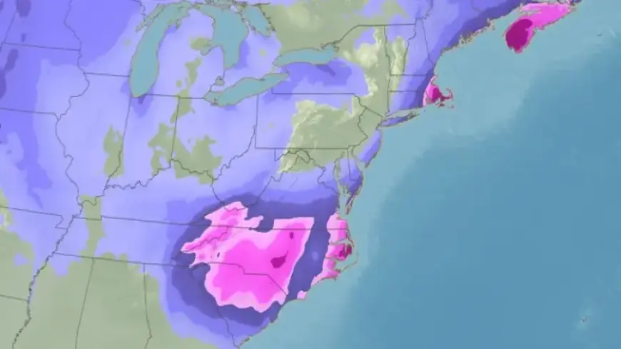
A low-pressure system will form near the Carolinas’ coastline on Saturday. As it rapidly intensifies into a bomb cyclone, blizzard conditions are predicted for southeast Virginia and northeast North Carolina by Saturday night. The storm’s trajectory is crucial; it will determine how much snow falls across the mid-Atlantic and Northeast regions.
Potential Impacts
- Coastal Flooding: Significant coastal flooding is likely along the Southeast and Mid-Atlantic coastlines.
- Winter Storm Watches: Over 25 million people across the Southeast, including cities such as Charlotte, Raleigh-Durham, Norfolk, and Atlanta, are under winter storm watches.
- Heavy Snowfall: Accumulation of snow and strong winds will start late Friday night into Saturday across parts of northern and eastern Georgia, the Carolinas, and southern Virginia.
Snowfall Predictions
The snow accumulation projections are still being confirmed, but the potential for hazardous travel is considerable. Cold air will ensure that any snowfall sticks to surfaces, leading to dangerous conditions. Cities such as Greensboro and Raleigh in North Carolina and Norfolk, Virginia, may see totals of half a foot or more, while areas farther inland may experience lighter accumulations.
Wind and Blizzard Conditions
Winds may gust up to 60 mph, particularly affecting coastal areas. This combination of snow and wind could lead to reduced visibility, fulfilling the criteria for a blizzard declaration.
Expectations for the Northeast
As the storm continues its northward path, its effects on the Northeast are still uncertain. Areas closer to the coast seem more likely to experience accumulating snow, while cities along the Interstate-95 corridor may have varied outcomes based on the storm’s exact location. Forecast models indicate that Boston may see more snow due to its eastern positioning.
Coastal Warnings
Coastal impacts are becoming increasingly concerning as the storm intensifies offshore. NOAA’s Weather Prediction Center warns that wind gusts could approach hurricane force, coinciding with high tides to produce significant flooding. Areas of particular concern include northeast North Carolina, the Virginia Tidewater region, and southeast New England.
Final Thoughts
Residents from the Carolinas to the Northeast should closely monitor the evolving forecasts. Preparation is key, ensuring safety during what could be a severe winter weather event.