


Oswego County Braces for More Lake-Effect Snow: Up to 2 Feet Forecast
Oswego County is preparing for a significant bout of lake-effect snow, with forecasts predicting up to 2 feet of accumulation. Weather warnings remain active as dangerously cold temperatures persist in the region.
Weather Warnings and Advisories
A lake-effect snow warning is in effect for Cayuga and Oswego counties until 7 p.m. on Thursday. Previously, Jefferson and Lewis counties were also under a warning, which has now been canceled.
Snow Accumulation Estimates
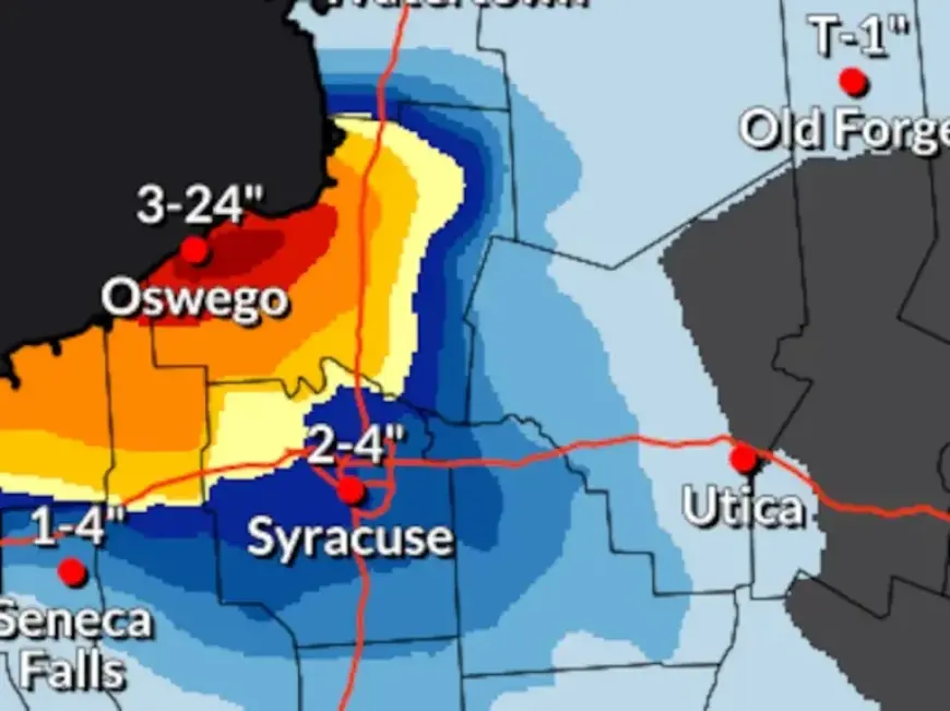
- Oswego County is expected to receive an additional 1-2 feet of snow.
- The northern tip of Cayuga County could see nearly a foot of snow.
- The city of Oswego has already recorded about 27 inches of snowfall since Sunday.
Impact on Local Areas
As of Thursday morning, Oswego County and far northern Cayuga County were experiencing intense snowfall, with rates reaching up to 3 inches per hour along the shoreline. School closures and delays are again affecting Oswego County.
Forecast for Snow Shifts
By midday Thursday, the snow band is anticipated to shift southward across Lake Ontario. Heavy snowfall will extend along the southern shoreline through Saturday morning. Areas from Monroe County eastward should expect 6 to 12 inches of additional accumulation over the weekend.
Temperature Extremes and Cold Weather Advisories
An arctic airmass is predicted to maintain well below-normal temperatures through the weekend. Wind chills are expected to dip below zero, with temperatures in the negative teens during the night.
- Thursday night into Friday morning may see wind chills between minus 20 and minus 30 degrees.
Cold weather advisories are in effect across the entire region from 7 p.m. Thursday until 10 a.m. Friday.
Residents of Oswego County should prepare for hazardous weather conditions as they brace for more lake-effect snow and severe cold.